Advisory Archive

There was no new snow in the last 24-hours except an inch of pixie dust in the Lionhead Range. Temperatures are in the single digits F and winds are 5-10 mph from the southwest to southeast. Today, high temperatures will be in the upper teens to 20 F, winds will be 5-10 mph from the southeast and our next chance for snow will be Wednesday.


This morning the mountains have no new snow. Temperatures are single digits to teens F. Wind is west-southwest at 5-15 mph with gusts to 25 mph. Today will be mostly sunny with temperatures in the teens to low 20s F and westerly wind at 5-15 mph with gusts to 25 mph. The next chance for snow is late Wednesday in the south of our advisory area and Thursday in the north.


Since yesterday morning the mountains received no new snow, except for a trace at Big Sky. This morning temperatures are single digits to teens F, and wind is out of the north and west at 5-15 mph. Today will have clearing skies with temperatures in the teens to low 20s F and northerly wind at 0-10 mph. The next chance for snow is Wednesday.


At 5 a.m. the mountains have 1-2” of snow with Cooke City getting 3”. Winds are eerily light at 5-15 mph from the SW with mountain temperatures in the mid-teens F. Today will remain calm and skies will turn partly sunny as temperatures rise into the low 20s. A trace of snow may fall tonight, but no accumulation is expected until early next week.


At 5 a.m. skies are partly cloudy, wind is westerly at 10-20 mph with gusts of 30 mph and mountain temperatures are in the high teens. Today, clouds will increase and snowfall will start later this afternoon with light westerly wind and temperatures of 20F. By tomorrow morning there will be 3-4” of new snow in the northern areas and 2-3” in the southern ranges. The storm will end early tomorrow morning and the weekend looks to be sunny.
There was no new snow in the last 24-hours, temperatures are in the single digits to 20 F and the wind is blowing 15-25 mph from the southwest to northwest. Skies today will be partly cloudy, temperatures will be in the 20s F, and the wind will be 15-25 mph from the west to southwest. The next snowstorm arrives tonight and there will be a trace to 1” of snow by morning.

An additional 1 to 3” of snow in the mountains fell yesterday before the storm ended. This morning, temperatures are in the single digits F and the wind is blowing 5-15 mph from the west to northeast. Skies will clear through the day with temperatures reaching the low 20s F and the wind will shift to the southwest and increase to 10-20 mph in the afternoon. The next chance for snow will be Thursday into Friday.

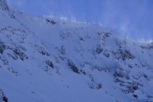
At 6am the mountains have 6” of new snow in Hyalite, 4” near Cooke City, and 1-2” elsewhere. Temperatures are single digits to teens F, and wind is northwest at 10-20 mph with gusts to 30 mph. Yesterday afternoon winds gusted 40-60 mph. Today, snow is expected with temperatures in the teens to low 20s F and northwest wind at 15-30 mph. Through today, 3-6” more snow is possible near Bozeman, Big Sky and Cooke City with 1-2” near West Yellowstone.

The mountains received no new snow during the last 24 hours. This morning temperatures are teens to low 20s F. Wind is west-northwest at 15-20 mph with gusts of 30-45 mph near Bozeman and Big Sky, and 5-15 mph with gusts to 20 mph near Cooke City and West Yellowstone. Today temperatures will be mid-20s F and wind will be west-northwest at 20-35 mph with gusts to 45 mph. Snowfall will begin later this morning and continue through tomorrow. The mountains near Bozeman and Cooke City are expected to get 5-7” by tomorrow morning with 3-6” during the day tomorrow. Near Big Sky and West Yellowstone can expect 2-4” by morning and 1-3” tomorrow.


Last night snow showers delivered 3-4” to the mountains near Bozeman with 1-2” elsewhere. This morning, temperatures are teens to low 20s F and wind is west-northwest at 10-15 mph with gusts to 30 mph. Today under partly cloudy skies, temperatures will be in the 20s F and wind will be west-northwest at 10-15 mph with gusts to 25 mph. Snow showers tomorrow will deliver less than an inch by morning, and heavy snowfall is expected late tomorrow into Monday.