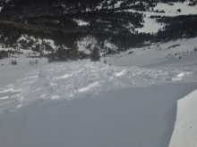
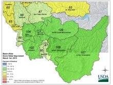
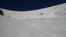
Advisory Archive
At 4 a.m. mountain temperatures are in the mid to upper 30s F with the exception of Cooke City where temps are in the upper 20s F. Winds are increasing out of the W-SW blowing 15-30 mph with gusts in Hyalite and Big Sky reaching over 40 mph. Today, near record highs will impact southwest Montana. Temperatures in the valley will reach close to 70 degrees F while mountain temperatures will warm into the mid-40s to low 50s F. Winds will continue to blow 15-30 out of the W-SW with gusts reaching over 40 mph in upper elevation terrain. Skies will start out partly cloudy this morning, but will become increasingly cloudy throughout the day. No precipitation is expected over the next 24 hours, but a good shot of moisture is forecasted to arrive Sunday night into Monday.
Clear skies overnight helped temperatures drop into the mid to upper 20s F this morning. Winds were blowing 5-10 mph from directions all around the compass. The Bridger Range had stronger winds blowing 10-25 mph. Today will have sunshine, light winds and warm temperatures. Temperatures will climb into the 40s F with winds of 5-10 mph that should shift to the S. This weekend should have more sun on Saturday and a good chance of precipitation coming Sunday.
This morning Big Sky and Cooke City received an inch of snow. Other places may have been dusted. Temperatures were in the high 20s and low 30s F, and winds were blowing 15-20 mph from the WSW. Don’t get your hopes up for snowfall today. An inch of snow may fall at most. Otherwise, clouds will linger over the area and give way to more sunshine for Friday. Today temperatures should climb into the 40s F with winds blowing 10-15 mph from the WNW. Long term weather forecasts are not too reliable, but we’re desperate. Weather models are showing a decent chance for snow starting Sunday night. We’ll see.

Yesterday, under sunny skies, mountain temperatures hit the high forties with southwest winds blowing 15-20 mph. Clouds rolled in last night and at 5 a.m. temperatures are near freezing except in the Bridger Range where they are in the upper thirties. Today will be mostly cloudy with mountain temperatures once again skirting 50F as winds remain light out of the southwest. Late tonight an inch of snow may fall, or a little rain depending on the freezing level which is forecasted to be around 7,500 feet. Light precipitation will continue into the morning; enough accumulation to be annoying but not enough for a round of high fives.
Sunny skies and above average temperatures are the norm right now. Mountain temperatures reached into the low 40s yesterday with southwest winds blowing15-20 mph and gusts of 30 mph. This morning temperatures have cooled into the upper 20s. Today will reach close to 50F under sunny skies with light southwest winds. Clouds and isolated showers are expected Wednesday night, but until then, enjoy the summer.
High pressure continues to dominate the weather pattern. This morning temperatures are in the 20s F under clear skies and winds are blowing 10-20 mph out of the west. Today, temperatures will be 10-15 degrees above average warming into the mid to upper 40s F. Skies will remain mostly clear and winds will continue to blow 10-20 mph out of the west. Spring like conditions will continue over the next few days.
Mountain temperatures this morning are in the mid-20s F and winds are blowing 10-20 mph out of the W-NW. Today, temperatures will warm into the 30s and 40s F under partly cloudy skies and winds will continue to blow 10-20 mph out of the W-NW. A quiet weather pattern will remain parked over the area for the next few days.
Mountain temperatures this morning were in the mid-20s F with westerly winds blowing 10-20 mph. Today should have some clouds, temperatures rising into the 30s and 40s F, and winds continuing 10-20 mph.

This morning temperatures were almost 10 degrees warmer than yesterday morning. Temperatures in most places were near 20 degrees F and ridgetop winds were blowing 20-30 mph from the NW in some locations and SW in others. Winds and temperatures were a little calmer and cooler near West Yellowstone and Cooke City. Today will be similar to yesterday but warmer. Temperatures will be in the 30s and 40s F, and winds should blow 20-30 mph at ridgetops mostly from the W and NW.
The only notable change in the weather is that winds increased overnight mostly near Bozeman and Big Sky blowing 20-40 mph from the W with temperatures in the teens F. Further south temperatures were in the single digits F, and winds were blowing 5-15 mph from the W. A ridge of high pressure over the area today will bring sunny skies and temperatures warming into the upper 20s and low 30s F with strong winds continuing from the W.