Good morning. This is Ian Hoyer with the Gallatin National Forest Avalanche Forecast on Saturday, February 5th, at 7:00 a.m. This information is sponsored by Yellowstone Club Community Foundation and Montana State Parks. This forecast does not apply to operating ski areas.
Three inches of snow fell last night near Cooke City with one inch near West Yellowstone, while the mountains around Bozeman and Big Sky stayed dry. Temperatures this morning are in the teens and 20s F. Westerly winds are at 20-30 mph with gusts of 35-55 mph, except for around Cooke City where they only 10 mph with gusts of 25 mph. Moderate west winds will continue today with gusts backing off a bit. A trace to an inch of snow will fall across most of the advisory area today with 1-2” accumulating by tomorrow morning. Around Cooke City 4-6” of new snow will fall today with 6-8” by tomorrow morning.
It is snowing this morning near Cooke City with 3 inches already on the ground at 6 am and another 4-6 inches on the way today. This new snow is falling onto a snowpack with weak layers (surface hoar and near surface facets) buried 12-18 inches down. Skiers yesterday in Yellowstone National Park (outside of the advisory area) intentionally triggered several small avalanches on these layers (photo). As snow accumulates today it will become possible to trigger larger slides on more slopes. After a long period of relatively stable conditions it’s time to tone back your objectives. Avalanches breaking on these weak layers are often wider than you’d expect and surprise even the most experienced backcountry travelers. The avalanche danger will rise to MODERATE near Cooke City as snow falls today.
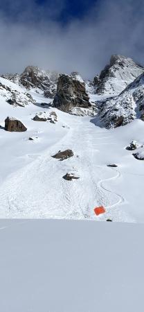
The 10” of snow that fell earlier this week has been blown into drifts where you could still trigger an avalanche. Yesterday, in Hyalite several groups of skiers and riders got unstable snowpack test results on weak layers in the upper snowpack and triggered small avalanches in wind-drifted pockets (photo). With very strong winds overnight expect to find similar conditions again today. Avoid wind drifted pillows and watch for cracks shooting out in front of you as an indication that you’ve found unstable snow and should stay off steep slopes. Triggering avalanches remains possible on wind-loaded slopes where the avalanche danger is MODERATE. On non-windloaded slopes the danger is LOW.
The mountains near West Yellowstone got less snow earlier this week (5-6”). While strongs winds have drifted this snow into cohesive slabs, these slabs will generally be too thin to be a significant hazard. If you find an isolated area with more than a few inches of drifted snow carefully evaluate the snowpack before committing to steep terrain. Large avalanches are unlikely and the avalanche danger is LOW
If you get out, please send us your observations no matter how brief. You can submit them via our website, email (mtavalanche@gmail.com), phone (406-587-6984), or Instagram (#gnfacobs).
TODAY! King and Queen of the Ridge at Bridger Bowl.
Good luck to everyone who is hiking and fundraising for the Friends of the Avalanche Center. In the spirit of the Olympics, the trail will be in fast condition and perhaps a new world record will be set!
Upcoming Education Opportunities
See our education calendar for an up-to-date list of all local classes. Here are a few select upcoming
February 10th, Forecaster Chat at Uphill Pursuits, “Beyond the Beacon” with GNFAC Forecaster Dave Zinn
Every Saturday near Cooke City, 10 a.m.-3 p.m. FREE snowpack update and transceiver/rescue training. Stop by for 20 minutes or more at the Round Lake Warming Hut.
Do you want to take an avalanche class? It can be a bit confusing trying to understand the different levels and types of classes. Sarah Carpenter explains it well in this article.