Good Morning. This is Eric Knoff with the Gallatin National Forest Avalanche Advisory issued on Saturday, February 3rd at 7:00 a.m. Today’s advisory is sponsored by Yellowstone Ski Tours and PH D Skis. This advisory does not apply to operating ski areas.
Over the past 24 hours the mountains around Cooke City received over a foot of new snow while all other areas picked up 2-4”. Currently, temps range from the teens to mid-20’s F and westerly winds are blowing 15-35 mph with gusts around Big Sky and Hyalite breaking 40 mph. Today, snow will continue around Cooke City with an additional 3-5” likely by this evening and another 3-5” overnight. Snow will develop over the rest of the advisory area by this afternoon. The mountains around Bozeman and Big Sky will see 2-4” by tomorrow morning while the West Yellowstone area will pick up 1-3”. Highs today will warm into the upper 20’s to low 30’s and winds will remain moderate to strong out of the W-NW.
The equation is pretty simple around Cooke City. Heavy snow and strong winds are creating very dangerous avalanche conditions. Over the past 24 hours more than a foot of snow has fallen totaling 1.1” of SWE. This heavy shot of snow was accompanied by strong winds out of the west. Today, I expect natural and human triggered avalanches to occur on wind loaded slopes. Avoid all wind loaded terrain and be extra cautious when traveling in avalanche run out zones (video).
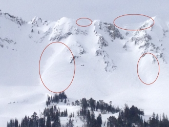
Non-wind loaded slopes also pose a significant avalanche threat. Storm slabs will be easy to trigger in steeper terrain. Yesterday, Alex skied up Republic Creek south of town and found steep, non-wind loaded slopes to be touchy to human triggers. I expect steep slopes to be even more reactive today. Slides have the potential to step down to buried surface hoar 2-3’ deep or weaker layers near the ground (photo, photo). Today's a great day to seek out lower angle terrain while practicing cautious route-finding and conservative decision making.
Today, very dangerous avalanche conditions exist on wind loaded slopes which have a HIGH avalanche danger. Non-wind loaded slopes have a CONSIDERABLE avalanche danger.
Today, wind loaded slopes are the main concern in the mountains around West Yellowstone. Four to six inches of new snow over the past few days combined with moderate to strong winds out of the west will create a fresh batch of wind slabs (photo). Watch for wind loaded slopes below ridgelines and on the leeward side of cross-loaded terrain features.
Buried surface hoar continues to produce unstable test results and is the main layer of concern. This pesky weak layer does not exist on all slopes so digging a pit and doing a quick stability test is an easy way to stack the deck in your favor. (video, photo). Facets near the ground are getting stronger, but still hold the potential to produce large slides in isolated areas.
Today, human triggered avalanches are possible and the avalanche danger is rated MODERATE.
Yesterday's fast moving storm dropped 6” inches of snow in the Bridgers and 3-5” around Hyalite and Big Sky. The new snow was easily transported by strong westerly winds. Yesterday, both Big Sky and Bridger Bowl Ski Patrols found wind loaded slopes to be reactive during control work. Slides are staying confined to the new snow, but have enough volume to carry and potentially bury a skier or rider. Warm temps will make wind slabs a little stubborn, but they still can’t be trusted, especially in steep high consequence terrain (think Saddle Peak). The snowpack is mostly stable on non-wind loaded slopes (video).
Today, the avalanche danger is rated MODERATE on all wind-loaded slopes and LOW elsewhere. The avalanche danger could rise if this evening’s storm arrives earlier than forecasted.
If you get out and have any avalanche or snowpack observations to share, drop a line via our website, email (mtavalanche@gmail.com), phone (406-587-6984), or Instagram (#gnfacobs).
Today! King and Queen of the Ridge
King and Queen of the Ridge. A Hike and Ski/Ride-a-Thon fundraising event to support the Friends of the Gallatin National Forest Avalanche Center. Join the party today at Bridger Bowl.
Upcoming Avalanche Education and Events
BOZEMAN
Feb. 6th, Sidecountry specific avalanche awareness for family and friends. 6-8 p.m. @ Beall Park
Feb. 7th, Woman’s specific avalanche awareness, 6-7:30 p.m. @ REI in Bozeman
Feb. 7th, Avalanche awareness, 6-7:00 p.m. @ Roskie Hall MSU
Feb. 9 and 10, Companion Rescue Clinic, Info and Register
Feb. 28th, Know Before You Go avalanche awareness, 7:00 p.m. @ Procrastinator Theater, MSU
March 2nd, Avalanche Awareness, 6-7:00 p.m. Bozeman Split Fest
March 7th, Avalanche Awareness, 6-7:30 p.m. @ REI
PHILLIPSBURG
Feb. 8th, Avalanche Awareness, 6:30-8:30 p.m. @ the new Fire Hall
DILLON
Feb. 24th and 25th, Snowmobile intro to avalanches w/ field course. More info: https://msuextension.org/conference/.
WEST YELLOWSTONE
Today, Avalanche Awareness, 7-8 p.m. at West Yellowstone Holiday Inn Conference Center
Feb. 10th, Avalanche Awareness, 7-8 p.m. at West Yellowstone Holiday Inn Conference Center
COOKE CITY
Every Friday and Saturday, Current Conditions Update and Avalanche Rescue, Friday 6:30-7:30 p.m. at The Soda Butte Lodge in February. Saturday anytime between 10-2 @ Round Lake.
Check out this blog post by Evelyn Lees at the Utah Avalanche Center on “Avalanche Fatalities During Uphill Travel.” One third of tourers die on the ascent, a surprisingly high statistic.