Good Morning. This is Eric Knoff with the Gallatin National Forest Avalanche Advisory issued on Thursday, February 1st at 7:00 a.m. Today’s advisory is sponsored by Community Food Co-op and Swiss Fit Montana. This advisory does not apply to operating ski areas.
Over the past 24 hours the mountains south of Bozeman picked up 1-2” of new snow. At 5 a.m. skies are partly cloudy and temps range from the single digits to low teens F. Winds are blowing 15-25 mph out of the W-NW with gusts around Big Sky reaching 40 mph. Today, Temps will warm into the upper teens to low 20’s F and winds will blow 15-30 mph out of the W-NW. Skies will become mostly cloudy by this afternoon as the next storm system approaches. Light snow develops tonight and the mountains will see 1-3” by tomorrow morning.
Snow stability is variable in the mountains around Cooke City. Some slopes have a deep and stable snowpack, while others have buried weak layers capable of producing avalanches. A layer of surface hoar 1-2’ deep has produced unstable results in stability tests and may be the culprit of recently triggered avalanches (photo, photo). This layer has sporadic distribution making careful snowpack evaluation essential.
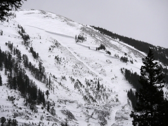
Facets buried deeper in the pack also remain a concern. A large natural avalanche on Woody Ridge south of town is a good reminder of what’s still possible (photo). Today, the likelihood of a triggering a slide increases on wind loaded slopes. Watch for and avoid wind loaded areas and assess non-wind loaded slopes carefully before traveling in avalanche terrain.
Read a recent blog post on the complexities of the snowpack around Cooke City: https://www.mtavalanche.com/blog/additional-thoughts-regarding-my-uncertainty-surrounding-cooke-city-snowpack
For today, the avalanche danger is rated CONSIDERABLE on wind loaded slopes and MODERATE on non-wind loaded slopes.
The snowpack is getting stronger in the southern ranges (video), but there are isolated instabilities too look for. On Tuesday, Doug and I skied into Bacon Rind in the southern Madison Range and had a layer of surface hoar propagate in our stability test (video, photo). Alex also got unstable results on this layer near West Yellowstone earlier in the week (video). Buried surface is not producing widespread instability, but should be looked for and assessed before riding steeper slopes. In addition to buried surface hoar, wind slabs could also produce human triggered slides. Fresh wind slabs most likely exist on slopes leeward to west-northwest winds. Avoid slopes below cornices or any areas that have large pillows of wind drifted snow.
Today, buried surface hoar and wind slabs make human triggered avalanches possible and the avalanche danger is rated MODERATE.
The primary avalanche problem in the mountains around Bozeman and Big Sky is wind slabs. On Tuesday, 3-5” of low density snow fell across the northern areas. This snow was transported onto leeward slopes by moderate to strong winds out of the west-northwest. Yesterday, my partner and I skied around Mt Blackmore in Hyalite and observed large cornices and wind loading along the ridgelines (video). While many wind-loaded slopes will be stubborn to trigger, some could avalanche from the weight of a skier or rider. Search for wind-loading in gullies, on roll-overs, and of course, under ridgelines (photo). Outside of wind loaded slopes, the snowpack is mostly stable.
For today, the avalanche danger is rated MODERATE on all wind-loaded slopes and LOW elsewhere.
If you get out and have any avalanche or snowpack observations to share, drop a line via our website, email (mtavalanche@gmail.com), phone (406-587-6984), or Instagram (#gnfacobs).
King and Queen of the Ridge
King and Queen of the Ridge, Saturday, February 3rd. A Hike and Ski/Ride-a-Thon fundraising event to support the Friends of the Gallatin National Forest Avalanche Center. Sign up and start collecting pledges HERE.
Upcoming Avalanche Education and Events
BOZEMAN
Feb. 6th, Sidecountry specific avalanche awareness for family and friends. 6-8 p.m. @ Beall Park
Feb. 7th, Woman’s specific avalanche awareness, 6-7:30 p.m. @ REI in Bozeman
Feb. 7th, Avalanche awareness, 6-7:00 p.m. @ Roskie Hall MSU
Feb. 9 and 10, Companion Rescue Clinic, Info and Register
Feb. 28th, Know Before You Go avalanche awareness, 7:00 p.m. @ Procrastinator Theater, MSU
March 2nd, Avalanche Awareness, 6-7:00 p.m. Bozeman Split Fest
March 7th, Avalanche Awareness, 6-7:30 p.m. @ REI
PHILLIPSBURG
Feb. 8th, Avalanche Awareness, 6:30-8:30 p.m. @ the new Fire Hall
DILLON
Feb. 24th and 25th, Snowmobile intro to avalanches w/ field course. More info: https://msuextension.org/conference/.
WEST YELLOWSTONE
Feb. 3rd, Avalanche Awareness, 7-8 p.m. at West Yellowstone Holiday Inn Conference Center
Feb. 10th, Avalanche Awareness, 7-8 p.m. at West Yellowstone Holiday Inn Conference Center
COOKE CITY
Every Friday and Saturday, Current Conditions Update and Avalanche Rescue, Friday 6:30-7:30 p.m. at The Soda Butte Lodge in February. Saturday anytime between 10-2 @ Round Lake.
Check out this blog post by Evelyn Lees at the Utah Avalanche Center on “Avalanche Fatalities During Uphill Travel.” One third of tourers die on the ascent, a surprisingly high statistic.