Good Morning. This is Eric Knoff with the Gallatin National Forest Avalanche Advisory issued on Saturday, January 9, at 7:30 a.m. K2 Café & Deli, in cooperation with the Friends of the Avalanche Center, sponsor today's advisory. This advisory does not apply to operating ski areas.
The high pressure that has been parked over southwest Montana for the past few days will begin to break down today as a weak weather disturbance moves in from the west. Today the temperature inversions will ease, allowing both valley and mountain temperatures to climb into the mid to high twenties with lows staying well above zero. Winds will increase from the west this morning reaching 15-20 mph along the ridgetops. Light precipitation could arrive with the front, with the potential of only a trace of new snow. Winds and precipitation will begin to taper off by late this afternoon, with cloudy skies and mild temperatures lingering through Sunday morning. Another ridge of high pressure will begin to build over the region on Sunday afternoon, providing sunny skies and warmer weather for early next week.
A blanket of weak faceted snow covers our advisory area from the Bridger Range to Cooke City. Whether it is depth hoar near the ground or a thin layer of facets found mid way through the pack, all weak layers have one thing in common - they can fail and produce avalanches. The predominance of weak snow over our entire advisory area in conjunction with large storms over the past two weeks has created severely hazardous avalanche conditions. In these conditions, the snowpack isn't picking sides. Any slope steeper than 30 degrees of any aspect has the potential to avalanche, be it sunny slopes or shady slopes, big slopes or small, all have the capability of failing under the right trigger.
Over the past few days Big Sky, Moonlight Basin and Yellowstone Club ski patrols have all reported triggering large avalanches with ski cuts and explosives. S-SE facing slopes have been the most active due to an extremely weak snowpack and wind loading from the N-NW winds of the last storm. These patrols also reported observing some of the largest natural avalanches they have ever seen on the surrounding mountains. The Bridger Bowl Ski Patrol also reported widespread activity while doing control work and witnessed a large natural avalanche off Saddle Peak that deposited large debris piles under the lowest cliff band. Strong winds in the Bridgers over the past few days have developed stiff wind slabs in the upper elevations and have made control work in the Slushman's area time consuming and difficult.
Natural and human triggered avalanches have also been reported from Buck Ridge to the Lionhead as well as Cooke City. One natural avalanche observed off the Lionhead ridge broke hundreds of feet across and up to six feet deep (photo). A skier in Cooke City witnessed several natural avalanches off Miller Peak, which created an almost continuous crown a half mile in length (photo).
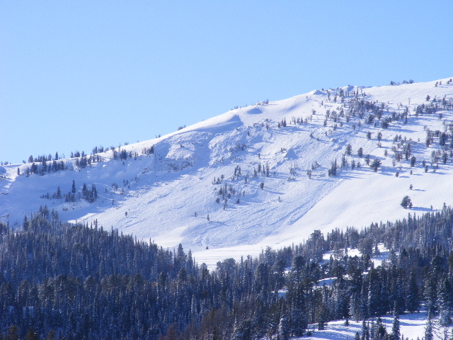
Remnants of natural avalanche activity such as crowns and debris piles will be visible throughout our forecast area. Remember signs of natural activity are the first and most obvious clue the snowpack is unstable. It may be easy to think that if a slope hasn't avalanched already than it must be stable, but this may result in deadly consequences. Slopes that sit next to an existing avalanche or have a similar orientation to slopes that have avalanched are ripe to do the same. Dense trees and tracks on a slope may also lead to a false sense of security, but with a snowpack this unstable avalanches are possible no matter how many tracks or trees are on the slope (photo).
Slopes steeper than 30 degrees throughout our forecast area warrant a cautious and conservative approach. If you have not practiced with your rescue gear now is a great time to do so. For today, human triggered avalanches are probable over our entire advisory area and the avalanche danger is rated CONSIDERABLE.
I will issue the next advisory tomorrow morning at 7:30 a.m. If you get out in the backcountry give us a call or email with your observations. You can reach us at 587-6984 or email us at mtavalanche@gmail.com.