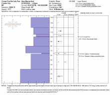
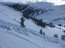
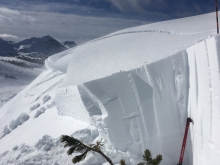
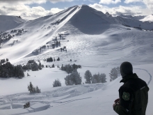
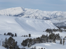
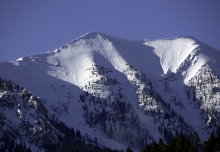
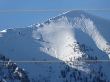
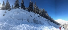
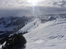
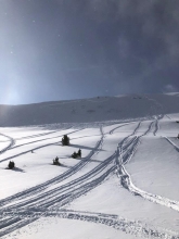
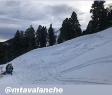
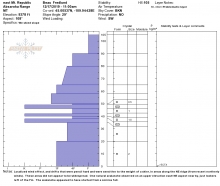
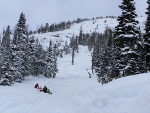
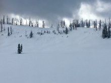
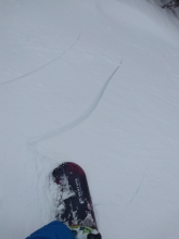
All Avalanche Incidents for Advisory Year 20 19-20
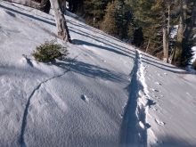
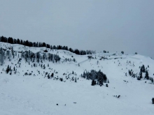
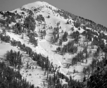
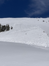
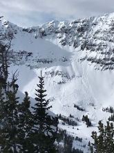
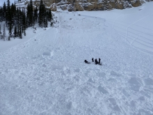
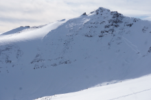
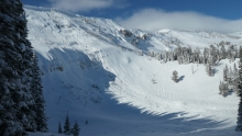
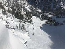
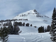
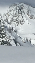
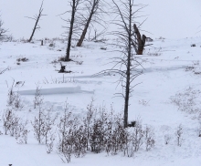
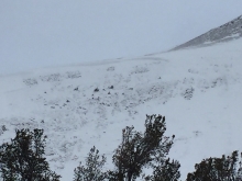
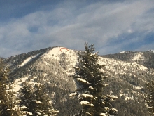
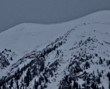
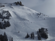
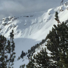
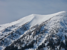
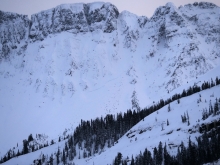
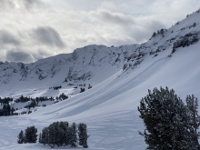
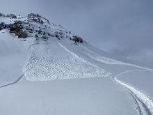
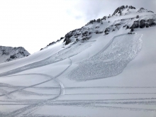
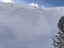
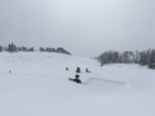
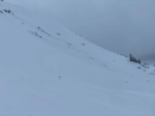
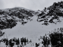
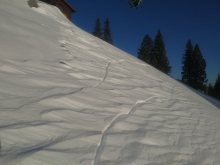
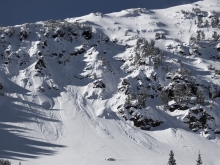
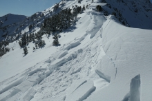
SS-AMu-R2-D2-O
Elevation: 8,900
Aspect: SW
Coordinates: 45.1771, -111.4350
Caught: 0 ; Buried: 0; Killed: 0
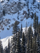
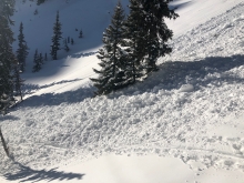
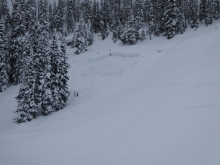
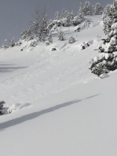
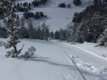
We saw a group of six snowmobilers who said they triggered these slides in McAtee Basin on the left side of the meadow on Saturday, Feb 8. I didn't see tracks up on the hill or sidehill tracks so they may have triggered the slope from the flats below. The debris runs all the way to the bottom of the hill.
More Avalanche Details
Caught: 0 ; Buried: 0
On private property, this small child triggered a slide and climbed out of the debris, not buried. A very close call! On the heels of this large snowstorm there are possibilities of children getting caught on road cuts or any open hill!
More Avalanche Details
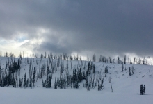
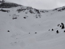
SS-N-D2-I
Elevation: 8,800
Aspect: NW
Coordinates: 45.4382, -110.9900
Caught: 0 ; Buried: 0
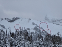
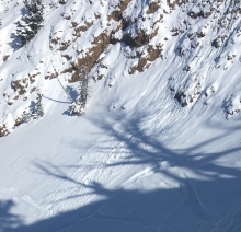
"Noted several avalanches (NW aspect ~ 8800') off of Elephant that traveled quite far into the trees where the summer trail typically runs, all appear to be new snow, D1- D2 in size, average 2' crowns, running on old/new interface from Feb 2. They appear to have run midstorm, sometime yesterday (photos 1,2,3). Above 9000', W Winds were crafting fresh wind slabs that were most reactive on a midstorm crystal/density change that buried a layer of stellars ~ 1' deep in shallower spots, topped with denser snow."
More Avalanche Details
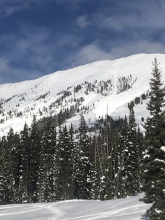
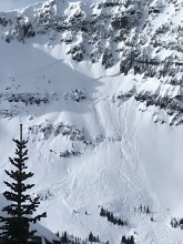
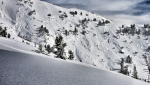
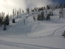
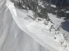
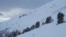
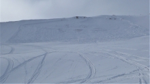
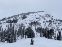
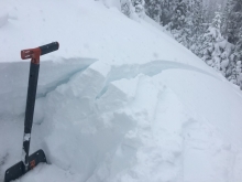
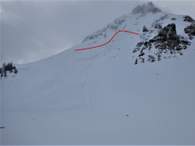
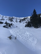
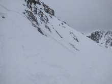
SS-N-R3-D2
Elevation: 8,000
Aspect: SE
Coordinates: 45.5097, -111.0820
Caught: 0 ; Buried: 0
"Noted two SS-D1.5/2 naturals (presuming based on lack of any sort of tracks) on Wheeler, typical spots for these conditions, both SE aspect around 8000'."
Dave Zinn dug a snowpit lookers right of the slides in the next path on Wednesday, 2/5, a couple days before the storm. He found weak snow that was ready to avalanche.
More Avalanche Details

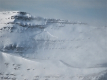
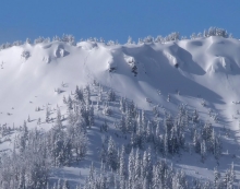
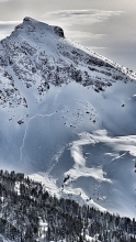
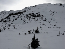
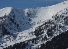
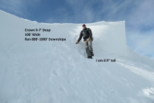
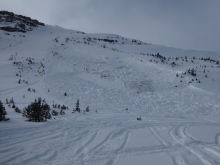
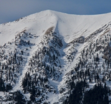
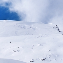
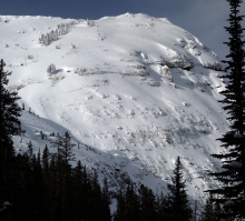
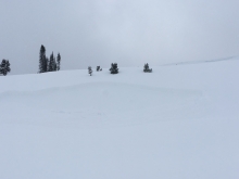
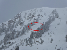
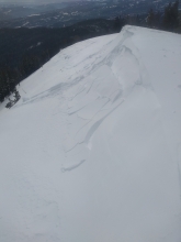
SS-N-R4-D2-O
Aspect: NE
Coordinates: 45.1719, -111.3800
Caught: 0 ; Buried: 0
Natural avalanche. North facing slope. Around half mile wide. Photos don't show half of the slide . Broke on the ground facets. Crown was between 3 and 15 feet deep. We didn't get a photo of the deepest crown. Ripped trees out around 5" diameter.
More Avalanche Details

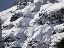
SS-N-R3-D2.5-U
Elevation: 7,900
Aspect: E
Coordinates: 45.8406, -110.9330
Caught: 0 ; Buried: 0
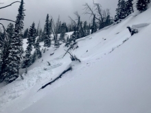
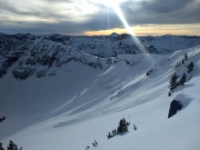
We saw three natural avalanche crowns on the afternoon of 2/7/2020. The north half of Texas meadow broke 3' deep and two small pockets in the playground looked to be 3' deep. North of Bridger Bowl on an East aspects at 7,500'-7,900'. They probably occurred within the last 24-36 hrs.
More Avalanche Details
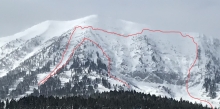
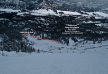
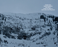
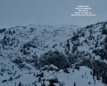
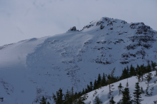
HS-N-R3-D3.5-O
Elevation: 8,900
Aspect: NE
Coordinates: 45.7943, -110.9360
Caught: 0 ; Buried: 0
A natural 4-8' deep slab avalanche broke on Saddle Peak within the last couple days (2/6 or 2/7) during the current storm. The mountains received 3-5 feet of snow equal to 3-5" of SWE over the last week with more snow in the forecast.
More Avalanche Details

SS-N-R3-D2.5
Coordinates: 45.8586, -110.9560
Caught: 0 ; Buried: 0
Large natural avalanche on 2/6/2020 in between Ross Peak and the Throne. Knocked down several trees in the runout.
More Avalanche Details
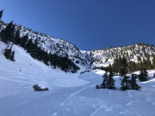
Coordinates: 45.5777, -110.9550
Caught: 0 ; Buried: 0
From observation: "We had cracks shooting around our skis for the entire skin up, and multiple wumphs"
More Avalanche Details
SS-ASu-R3-D2.5-I
Elevation: 7,500
Aspect: S
Coordinates: 45.8406, -110.9330
Caught: 0 ; Buried: 0
More Avalanche Details
Elevation: 6,000
Caught: 0 ; Buried: 0
On the drive to Buck Ridge there were widespread 4-6" deep natural s slab avalanches in the storm snow on steep slopes, road cuts and river cuts. Some broke "on the ground", where it was bare ground two days ago. This is some evidence of the upside down nature of this storm.
More Avalanche Details
SS-AMc-R2-D1.5-I
Elevation: 9,300
Aspect: NE
Coordinates: 45.1719, -111.3800
Caught: 0 ; Buried: 0
We triggered an avalanche in the second Yellow Mule off Buck Ridge on 2/6/2020. It is on a small roll/cor cornice n the flats". It broke within the current 2-3' storm snow,18-24" deep.
We also saw a couple natural avalanche crowns 10-18" deep lower down the drainage. I'm sure there were a ton more crowns there, and probably everywhere. through the forecast area. Visibility was limited to 50-100'.
More Avalanche Details

SS-AFu-R1-D1
Aspect: SW
Coordinates: 45.4472, -110.9620
Caught: 0 ; Buried: 0
"Additionally, on Wedensday my climbing partner and I dug an informal pit because we were concerned with accessing the lower pitches of the dribbles from the point the bootpack ended. We noticed that sugary layer some ways down and went around..when we tried to come up the from the southwest I caused another small slide that was significantly deeper than the one I sent you (2/02); I feel like if it had happened from where people normally cross to climb Dribbles it could have been bad."
More Avalanche Details
SS-N
Coordinates: 44.9041, -111.1850
Caught: 0 ; Buried: 0
This small natural avalanche was seen in Teepee basin on Tuesday, 2/4.
More Avalanche Details
Coordinates: 45.9684, -111.0210
Caught: 0 ; Buried: 0
Skiers around Frazier Basin and also at Flathead Pass reported collapsing and cracking as they skied. From Flathead pass, "Lots of collapses and whumphs. Obvious soft slab fractures in new and drifted snow. Saw evidence of point release avalanches on steeper terrain around cliffs. Also saw a crown that appeared to have triggered on the new wind loaded snow, NE aspect . It was approx. 200 feet below a steep rocky ridge."
More Avalanche Details
SS-N
Aspect: E
Coordinates: 45.7943, -110.9360
Caught: 0 ; Buried: 0
More Avalanche Details
SS-N
Aspect: E
Coordinates: 45.8586, -110.9560
Caught: 0 ; Buried: 0
This avalanche was seen on Tuesday, Feb 4 and likely released on Monday from the wind loading .
More Avalanche Details
SS-N-R3-D2.5
Aspect: W
Coordinates: 45.8139, -110.9330
Caught: 0 ; Buried: 0
1. "I saw two crowns from the ridge at 1430 today (2/4). One on the lower heavily wind loaded shoulder and one up high in the middle of the path. Not sure if they connected, or were separate. R3-D2.5. 2-4’ deep. The higher one was partially drifted in. My guess is ran yesterday with east winds or early today."
2. "Saw this looking south from top of the ramp into Jones creek. Looks to be just new snow but couldn’t see the whole crown or the sli slide th."
More Avalanche Details
SS-N
Aspect: E
Coordinates: 45.6553, -110.5580
Caught: 0 ; Buried: 0
East facing slope seen from Big Sky meadow after Sunday’s storm.
More Avalanche Details
SS-N-R1-D1-I
Elevation: 8,600
Aspect: SE
Coordinates: 45.0202, -109.9380
Caught: 0 ; Buried: 0
SEerly aspect around 8600'. A thinner, smaller storm s slab triggered by dry loose from above.
More Avalanche Details
HS-N-R2-D2-O
Elevation: 9,500
Aspect: W
Coordinates: 45.0202, -109.9380
Caught: 0 ; Buried: 0
West aspect around 9500'. Deep slab , mid-slope. Crown estimated to be 4-6' deep.
More Avalanche Details
HS-R3-D3-O
Elevation: 9,200
Aspect: SE
Coordinates: 44.5358, -111.5130
Caught: 0 ; Buried: 0
More Avalanche Details
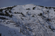
HS-N-R3-D3.5-O
Elevation: 8,600
Aspect: NE
Coordinates: 45.8926, -110.9620
Caught: 0 ; Buried: 0
Saw this today while skiing. This crown is on a northeast aspect at about 8600 feet. Crown height 6-8 feet. It is mid path in the Great One. It seems to have naturally avalanched on Sunday during the storm, without a cornice trigger , after the wind event. All I can get here is that the slope was overloaded from storm snow, on top of a recently overgrown hard slab . Looks like it initiated higher up and pulled out much deeper below. Definitely a large hard slab avalanche . HS-N-R3-D3.5. Debris made it to the trees in the historic path. Otherwise, northeast aspects are loaded above 8500 feet, and I saw about 14 inches of new at 8000 feet. No loading during the day today.
More Avalanche Details
SS-NIu-R1-D1
Aspect: W
Coordinates: 45.4472, -110.9620
Caught: 0 ; Buried: 0
"Climber caused icefall that triggered small avalanche. Thankfully, the bed surface was ice just a few inches down and belayer was just outside the path. Minor entrainment."
More Avalanche Details
SS-NC-R2-D2
Elevation: 8,400
Aspect: SE
Coordinates: 45.0256, -109.9370
Caught: 0 ; Buried: 0
The Nose of Town Hill avalanched on Feb. 1 due to the strong SWerly winds and looked to be triggered by a cornice fall (estimated 2-3' crown, about 75-100' wide.
More Avalanche Details
SS-N-R1-D1.5-I
Elevation: 9,400
Aspect: E
Coordinates: 44.9937, -109.9160
Caught: 0 ; Buried: 0
Winds Friday night transported snow creating fresh drifts that avalanched naturally over the weekend. We observed two wind slabs that released naturally on the east side of Woody Ridge both appear to be 2-3' deep and 50' wide.
More Avalanche Details
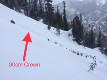
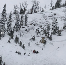
SS-AMu-R3-D1-S
Elevation: 10,000
Aspect: SE
Coordinates: 45.0525, -109.9620
Caught: 0 ; Buried: 0
R3/D1 wind slab off of the SE side of Crown Butte. Observed from Henderson, and there were numerous sled tracks in the debris/runout.
More Avalanche Details
HS-AMu-R3-D2.5-O
Elevation: 10,000
Aspect: SW
Coordinates: 44.9205, -111.2300
Caught: 0 ; Buried: 0
From Obs. form: "[Slope] Was marked up previously. We parked out near the bottom and a few guys not in our group start climbing. So we watch them climb. It breaks out. Guy ditches the sled and manages to stay up top. Sled goes down with the slide . Then the snow breaks in 2 other spots creating more slides."
From riders involved: "Yesterday we were the ones in the big sky avalanche. There was no markings on the spot we were climbing. Further down the mountains there were climbs at the same angles of this slope. Thankfully the rider was above the slide when it started and managed to stay on top. Rider walked down the debris and we found the sled lower down in the trees. No injuries."
More Avalanche Details
HS-NCu-R2-D3
Aspect: E
Coordinates: 45.2268, -111.5120
Caught: 0 ; Buried: 0
From Big Sky Ski Patrol: "Also saw a large slide on one of the far ridges of Cedar that was not there yesterday and appears to be cornice triggered."
More Avalanche Details
SS-N-R2-D2-I
Aspect: SE
Coordinates: 45.4472, -110.9620
Caught: 0 ; Buried: 0
From an observation: "We were up on the ridge off Palace Butte and saw this recent natural released slide . Crown was big in spots. Must have happened sometime over night or in the morning (1/29 or 1/30) perhaps from the recent wind loading . East, southeast facing, on the peak north of MT Bole."
More Avalanche Details
SS-N-R1-D1
Aspect: E
Coordinates: 45.0202, -109.9380
Caught: 0 ; Buried: 0
From email (1/30/2020): "2 natural avalanches that ran last night, just west of Cooke City. Both slides were on easterly aspects around 9500'."
More Avalanche Details
G
Aspect: N
Coordinates: 45.2981, -111.5240
Caught: 0 ; Buried: 0
From email: "There was a large avalanche on the north face of Fan. It is not on the NE Face that everyone skis, but out to the west of the north c couloir where there is a major ridge off the summit. North as aspect estimated at over 1K ft. wide, to the ground with a deep crown. Likely triggered by cor cornice ll."
More Avalanche Details
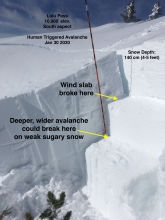
SS-AFr-R2-D2-S
Elevation: 10,000
Aspect: S
Coordinates: 45.0709, -109.9580
Caught: 0 ; Buried: 0
We triggered this avalanche of wind-drifted snow as we approached very carefully from a low angle slope above, on 1/30/2020. This was near Lulu Pass outside Cooke City on a south facing slope at 10,000'. It broke within recently drifted snow, but these slabs could be enough weight to break deeper and wider on sugary layers deep in the snowpack. I initially approached where the cor cornice s a little steeper (no overhang though), and then I got that funny feeling and backed off and went to safer feeling spot with the intention to dig at the top of the slope. It broke within the recent snow/wind load, and did not step down. It was about 100’ wide x 70’ long x 2-3’ deep.
More Avalanche Details


SS-AS-R1-D1-I
Elevation: 9,200
Coordinates: 45.4439, -110.9970
Caught: 0 ; Buried: 0
Snow picked up at Mt. Blackmore with calm to light winds. Someone up there before us pulled out a small wind loaded pocket on the face leaving the basin.
More Avalanche Details
HS-N-R2-D2.5-O
Coordinates: 45.8883, -110.9590
Caught: 0 ; Buried: 0
Avalanche crown visible near the top of Naya Nuki Peak in the Northern Bridgers. Estimated max crown depth of 10 ft, approximately 200 ft wide. Photo taken Jan 29th, 2020. Several inches of snow were on the debris, avalanche likely occurred on Monday, Jan 27th.
More Avalanche Details
N-R2-D2-O
Elevation: 9,900
Aspect: N
Coordinates: 45.4272, -111.0140
Caught: 0 ; Buried: 0
A skier saw this slide from the top of Mt. Blackmore on 1/25/2020.
More Avalanche Details
HS-ABc-R4-D4
Coordinates: 45.2760, -111.4360
Caught: 0 ; Buried: 0
A deep slab avalanche was triggered using explosives on 1/24/2020 in the North Summit Snowfield at Big Sky Resort.
From email: "The Whale came out close to 10’ deep that tapered to 3’ on the skiers right edge... It broke on basal facets, thin layer, 1F hard at crown (!) with very hard snow above and below the layer that failed .... It is likely that the layer that failed had some different characteristics lower in the path that avalanched away- possibly less hard."
More Avalanche Details
Coordinates: 45.8586, -110.9560
Caught: 0 ; Buried: 0
From email: "Went out to Ross Peak with some friends today, and we saw some alarming signs. Snowpack out there was really shallow, similar to the approach to the Throne. We got to the first major clearing at about 7500', which tops out at about 36 degrees at the steepest part. We opted to tuck back in to the trees to try to find a lower-angle route around the slope, but there wasn't really a better option. It is a really short (~50') but wide (~500') slope, and we decided it would be reasonable to cross it one at a time. I was setting the skin track and got a big collapse that scared the shit out of me. For some reason it didn't slide , but I measured a few angles and the area that collapsed was definitely at 34-36 degrees. Probably collapsed an area about 100' across. After I had a chance to clean out my long johns, we turned around and skied back down the skin track ."
More Avalanche Details
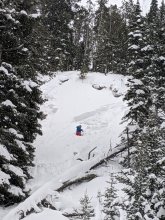
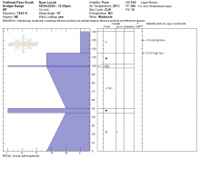
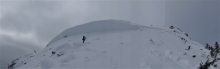
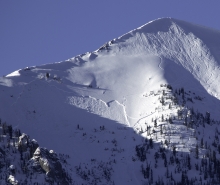
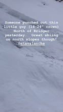
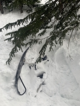
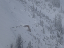
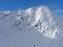
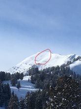
HS-AMu-R2-D2-O
Coordinates: 45.1771, -111.4350
Caught: 0 ; Buried: 0
From Instagram: "I watched a snowmobiler set this avalanche off today. Very scary in MT right now."
More Avalanche Details
HS-AM-R2-D2-G
Elevation: 8,800
Aspect: N
Coordinates: 44.7336, -111.3290
Caught: 1 ; Buried: 0
From email: "I wanted to make you aware of a snowmobile triggered
slide
in Lionhead today. Fortunately, I was not injured, was able to stay completely on top, climbed through the majority of the snow wash after seeing it begin to break, and relatively slowly slid down with the last of the moving snow while still on the machine. When I came to a stop I stood up and was completely free of the snow. Our group is trained in avalanche safety, practiced beacon use prior to leaving town in the morning, were wearing avy gear, and were very fortunate that this ended the way it did.
A clear reminder that this can happen to any of us and to be careful out there."
More Avalanche Details
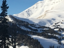
HS-N-R3-D2.5-O
Elevation: 10,000
Aspect: SW
Coordinates: 45.0530, -110.0100
Caught: 0 ; Buried: 0
A large natural avalanche observed on the southwest face of Wolverine Peak. Observed 1/20/2020. Photo: D. Wycoff
More Avalanche Details
HS-NO-R3-D2.5-O
Elevation: 9,800
Aspect: NW
Coordinates: 45.0270, -110.0030
Caught: 0 ; Buried: 0
A large natural avalanche observed on the northwest face of Median Peak on 1/20/2020. Photo: D. Wycoff
More Avalanche Details
HS-N-R3-D2.5-O
Elevation: 10,200
Aspect: N
Coordinates: 44.9952, -109.9080
Caught: 0 ; Buried: 0
Spotted the crown on our way down from Ripcurl yesterday, we got a closer look today when we toured into High Hayden. N aspect 10200'
More Avalanche Details
Aspect: W
Coordinates: 45.8535, -110.9700
Caught: 0 ; Buried: 0
From obs: "Took a tour down the ridge dividing Truman and Jones creek Sunday.Snow varied from 12 inches of facets topped with a crust to big solid wind deposits sitting on basal facets to 2 feet of fist and 4 finger snow over a 1 finger crust over more facets. Quite a bit of cracking and whoomphing on westerly and wnw aspects. I avoided the large paths altogether and stayed on the ridge."
More Avalanche Details
HS-AMu-R4-D2.5-O
Coordinates: 44.5477, -111.4860
Caught: 0 ; Buried: 0
Snowmobiler triggered avalanche near Reas Peak on Sunday, 1/19/20. he was able to ride through it uphill.
More Avalanche Details
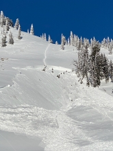
HS-R3-D2.5-O
Elevation: 10,000
Aspect: NE
Coordinates: 45.2263, -111.4960
Caught: 0 ; Buried: 0
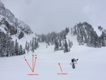
I was on the west side of Pioneer Mtn digging a pit for YC Ski Patrol. I heard a few groups of snowmobiles cruising around the foothills of cedar. I turned and saw two snowmobilers cresting the ridge above the slide pictured as the debris was settling down. The sledders enjoyed the view for a few minutes before turning back the way they came and stumbled upon the slide they had unknowingly triggered. They skirted around the side of the crown and stopped for a few minutes. Based on the height of the rider off his sled, I would estimate the crown to be roughly 10’ at its max height. NE as aspect elow Cedar
More Avalanche Details
Coordinates: 45.0607, -111.2720
Caught: 0 ; Buried: 0
Skied a lap at 44.96854,-111.272761. Two big collapses on the skin back up, and frequent shooting cracks. We were very glad to be skiing low angles.
More Avalanche Details
HS-ASu-R2-D2-O
Elevation: 8,000
Aspect: SE
Coordinates: 45.8406, -110.9330
Caught: 0 ; Buried: 0
A skier was skinning uphill, breaking trail and triggered this avalanche on 1/19/20. They reported, " released a small pocket near texas meadow. Maybe 50 ft wide, 2 ft crown and ran 150 ft....I was not caught and nobody was buried or injured. I was skinning up at about 1130...I got to where it was steeper and as I reached thinner snow near rocks I felt a whump. I took one more step and the pocket released."
More Avalanche Details
HS-NC-R2-D2-O
Elevation: 8,900
Aspect: NE
Coordinates: 44.7121, -111.3130
Caught: 0 ; Buried: 0
With only 3" of new snow overnight, a cornice triggered a large avalanche at Lionhead early this morning. It broke 3 to 4 feet deep and propagated on a buried weak layer . This is the only stability test we need today, human triggered avalanches possible and the management strategy is to avoid steep slopes or be clear about your risk tolerance if you are poking into avalanche terrain.
More Avalanche Details

Elevation: 8,500
Aspect: SE
Coordinates: 45.7701, -110.9400
Caught: 0 ; Buried: 0
From obs: "Observed whumping and cracking on a slope <25 degrees, E-SE facing. We were on top of the ridge in a safe place, but it was easy to see how a steeper slope could be triggered by someone on more mellow terrain below or off to the side. While traversing the ridge from the M to Bridger we observed multiple (past) cornice collapses that triggered small or no slides, but also a larger slide in the pinnacles."
More Avalanche Details
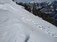
SS-AS-R1-D1.5-O
Coordinates: 45.5097, -111.0820
Caught: 0 ; Buried: 0
From obs: "Skied into to a pillow of snow. I think it started as just sluff but then broke off an avalanche. It was not wide but the crown is estimated at 2 feet. It was not moving fast and I just dug into the bed surface and slowly moved out of it. I was the second skier. The first skiers track did not go as deep as mine. failed on weak facets at the base of a steep roll over."
More Avalanche Details
SS-AMu-R2-D2-O
Elevation: 9,200
Aspect: NE
Coordinates: 45.0607, -111.2720
Caught: 0 ; Buried: 0
From obs: "2nd hand observation arrived at site about 5 minutes after slide . Triggered by sidehilling snowmobiler but was not caught up in it. looked approximately 50 ft wide 150 ft vertical. Did not appeared to be very deep."
More Avalanche Details
HS-ASu-R3-D2-O
Elevation: 9,800
Aspect: NE
Coordinates: 45.4351, -110.9440
Caught: 0 ; Buried: 0
From Obs: "... Our party of two was ascending southwest on a rib with the intention of reaching the ridgeline. At 9800', the upper member of our party triggered a D2.5 with an approximately 100' crown immediately to our south. Crown height appeared 2-3' and the slide traveled approximately a distance of 2,000' and 500 vertical feet down mountain. Within a few seconds, we remote triggered to the north a D3 with an approximately 200' crown. Crown height appeared up to 7' at highest point and slide traveled approximately 300 vertical feet down mountain. The remote triggered slide started approximately 15-20 feet to the north of the location of the lower member of our party, who was approximately 30 vertical feet below the upper member of our party. After the slide the upper member of our party noticed a shooting crack at his elevation. Two skiers and one dog were ascending below us. They observed the avalanche and later mentioned that they were approximately 150 feet in distance from the toe of the remote triggered slide , which completely covered their skintrack. Nobody caught or buried."
From group that was below: "Finished a snow pit at 45.434589, -110.940957. Results were ECT-X, Aspect : 110 deg, Angle: 27 degrees, Depth: 90 cm, Weak layer was above melt/freeze at 60 cm, fist hardness above 62 - 67 cm. Then fairly cohesive newer snow 70 - 90 cm. Weak layer did not budge, even when levered with the shovel.
Knowing there was one party of two ahead of us, we continued to 45.434716, -110.94124 when they triggered slide above. It ran through one of the avalanche paths behind us, that we had crossed. We whooped to see if someone was the trigger and if they were ok, they yelled back all was ok. Our mistake was assuming the party ahead was taking, what we consider to be, the standard route up Flanders, not the subtle ridge that we figured was loaded by the month of west/sw winds We were wrong and were traveling below them but still were traveling in the older trees and not in slide paths, yet another example of why you follow protocol. Anyways I took a bunch of pics. Pin on map is about where they triggered it."
More Avalanche Details

SS-ASc-R2-D2-U
Elevation: 9,600
Coordinates: 45.4054, -110.9750
Caught: 0 ; Buried: 0
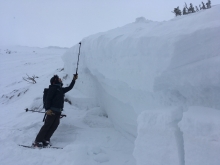
From obs: "There is a small east facing basin that’s between Divide Peak and Maid of the Mist Basin. While walking along the ridge that connects the two, my partner intentionally broke off a large piece of a co cornice which then triggered two substantially sized avalanches in the basin below. The first avalanche was directly beneath the collapsed co cornice ith a crown 6-12 inches deep and about 30 ft across. The second avalanche was triggered by the 1st avalanche and had a crown of similar depth but was substantially larger. It was hard to see as the crown travelled uphill and around a corner. The ascpet was E and SE, at the elevation of 9,600ft. The pictures I got are poor, but should give you an idea of the size."
More Avalanche Details
HS-NC-R2-D2-O
Elevation: 8,800
Aspect: NE
Coordinates: 45.7869, -110.9350
Caught: 0 ; Buried: 0
We saw this big natural avalanche at noon on January 18th. It broke late on 1/17/20 or early 1/18/20 after strong wind and new snow (1" SWE) heavily loaded slopes. Photo: GNFAC
More Avalanche Details
SS-N-R2-D2-O
Coordinates: 44.7145, -111.3180
Caught: 0 ; Buried: 0
Natural avalanche observed on 1/17 in Airplane Bowl off of Lionhead Ridge. Broke 2 ft deep and 150 ft wide.
More Avalanche Details
HS-N-R3-D3-O
Elevation: 9,000
Aspect: E
Coordinates: 45.9151, -110.9810
Caught: 0 ; Buried: 0
Natural avalanche on 1/17 near Hardscrabble Peak in the Northern Bridgers.
From observation: "At some point between 12:00 and 15:00 a large natural slide occurred in 'October Bowl'. My partner and I saw no tracks in the area. We witnessed a large amount of snow being deposited on that aspect throughout the day. In the photos you can see the crown from 01/16 and the new crown up and to the right."
More Avalanche Details
HS-NC-R4-D2.5-O
Elevation: 9,750
Aspect: NE
Coordinates: 45.0813, -109.9600
Caught: 0 ; Buried: 0
This avalanche was a hard slab of wind-loaded snow on a very steep (50 degree) slope with monster cornices above. NE facing, 9700’, and likely ran Wed or Thursday (1/15 or 1/16) deduced from snow on debris. It was co cornice riggered and ran on the facets near the ground, propagated 300’ wide, 150’ vertical and 3-6’ deep.
More Avalanche Details
N-R2-D2-O
Elevation: 9,700
Aspect: SE
Coordinates: 45.0530, -110.0100
Caught: 0 ; Buried: 0
"A south and southeast aspect of Mt. Wolverine around 9,500'-10,000'. I'd estimate the lower crown to be about 3' deep. And timing of the event maybe around Jan. 16.?" Photo: B. Fredlund
More Avalanche Details
HS-N-R3-D3-G
Elevation: 8,500
Aspect: E
Coordinates: 45.9103, -110.9780
Caught: 0 ; Buried: 0
"... while touring in the Northern Bridgers, my partner and I noticed a very large avalanche that occurred on a North face in "October Bowl" just to the south of Hardscrabble Pk. We didn't witness it and are unsure of a t trigger but we came in contact with all parties believed to be out there and assume it occurred naturally early this morning from heavy wind-l loading The crown seemed to be 2-3' deep but stepped down to the ground about 200' below the crown. The s slide was about 400' in width and ran about 1,000' and we assumed classifications of R3.5 and D3."
More Avalanche Details
HS-AMu-R4-D2.5-O
Elevation: 10,000
Coordinates: 45.0448, -109.9330
Caught: 0 ; Buried: 0
Two big avalanches were triggered on Henderson Mountain near Cooke City on 1/16/20. One was huge. The other was still big enough to bury or kill somebody. Nobody was reported caught or injured. Report and photos from a third party that did not witness the slides occur, but were in the area earlier this day and saw the slopes had not slid.
From forecaster site visit: "We parked near the bottom of the debris on the Henderson slide and climbed to the crown. Knife hard wind slab ; failed on facets at the ground that were 1F+ hardness (2-4mm). The crown was 5 meters deep (measured) and tapered to 16". There are lots of rocky and thin zones on this slope that were likely the trigger point . Vertical distance was 600', 1000 feet wide, debris was 10' deep."
More Avalanche Details

Elevation: 7,800
Coordinates: 45.0668, -111.0500
Caught: 0 ; Buried: 0
From an email:
HS above 8000' is 80-100cm. Down low its pretty thin and punchy but we were able to link together supportable sections for great ankle deep powder to the valley floor. Around 7800' we got one whoomph while skiing out.
More Avalanche Details
SS-ASc
Aspect: NW
Coordinates: 45.3453, -111.3750
Caught: 0 ; Buried: 0
From an observation form:
An intentional ski cut at the top of Bat Ears couloir produced a windslab avalanche with a crown 4-8inches deep and ran about as wide as the couloir . We then continued to ski down. Once in the bottom of Bear Basin, we could see a much larger avalanche that looked to be 1-2 days old. Its disjointed crown was some 150ft wide, but it was hard to tell how deep it was, as its crown was fairly far away and partly blown back in. Parts of the slide ran on the ground layer of facets but looked to be the result of wind load.
I do not have pictures of the Bat Ears crown that we triggered. We exited via Bear basin with our tails between our legs, and hope this bad idea on our part can help others make terrain choices this weekend.
More Avalanche Details
SS-N
Elevation: 9,600
Aspect: SE
Coordinates: 45.0303, -109.9980
Caught: 0 ; Buried: 0
Photo attached of a couple thin, natural slab avalanches near Cooke this morning. SE aspects of Mineral Mtn., around 9,600'.
More Avalanche Details
SS-ASu-R3-D2.5-O
Elevation: 8,600
Aspect: E
Coordinates: 45.7869, -110.9350
Caught: 1 ; Buried: 0
Skier triggered avalanche in Argentina Bowl on Saddle Peak. Observed from the highway. Occurred during the day on Wednesday, 1/15/2020.
From e-mail: "Skiers triggered two separate slides on south Saddle this afternoon. we witnessed the smaller slide to the lookers right of the big slide , the bigger one happened later apparently... The first smaller s slide was caused by a s ski cut near the trees, f fracture was about 2 feet, soft s slab that seemed to run on a thin s sun crust below the s sun crust was also very weak and sugary. Not sure when the second skier went farther out and triggered the whole bowl, but they got lucky!!"
More Avalanche Details
SS-AMu-R1-D1-G
Aspect: E
Coordinates: 45.0607, -111.2720
Caught: 0 ; Buried: 0
A small but relatively deep avalanche triggered by a snowmobiler on Tuesday, 1/14/2020. 30 ft wide. Ran 20 vertical feet. This avalanche broke to 2-3 ft deep, to the ground. This is the second time this year this slope has s slide it also avalanched in mid-December.
More Avalanche Details
HS-N-R4-D3-G
Aspect: NE
Coordinates: 45.1212, -109.9300
Caught: 0 ; Buried: 0
From an email:
From afar, observed a large R4/5 D3, to the ground, off of the entire NE shoulder of Fox Mtn. (see attached photo) as well as a couple of scattered R1/D1 wind slabs on upper elevations on E/NE aspects.
More Avalanche Details
L-AS-R1-D1-I
Elevation: 9,000
Coordinates: 45.3250, -111.3830
Caught: 0 ; Buried: 0
Small skier triggered loose dry avalanche observed on a south facing slope at about 9000' on the ridge separating Beehive and Middle basins.
More Avalanche Details
SS-ASr-R3-D2-I
Elevation: 8,370
Aspect: S
Coordinates: 45.0270, -110.0030
Caught: 0 ; Buried: 0
We toured into Meridian today. On our approach we remote triggered a soft slab on the climber’s left (west) side of the crux approach slope. It was 50’ wide, ran 150’, and the crown was about 12-15”. It was a south aspect a aspect ’ with a ~40 degree start zone. The storm slab ran o slab crust.
More Avalanche Details
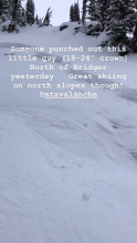
SS-AS
Coordinates: 45.8512, -110.9480
Caught: 0 ; Buried: 0
Skier triggered wind slab reported north of Bridger Bowl on 13 January. Photo: B. Henry
More Avalanche Details
N-R2-D2-O
Elevation: 9,150
Aspect: NE
Coordinates: 45.1858, -111.4170
Caught: 0 ; Buried: 0
We could see a few avalanches that likely broke yesterday on 1/11/2020.
- The wind pillow under the large cornices in 2nd Yellowmule broke. It looked like just the wind load, vs breaking at the ground. 200' wide x 150' vertical 1-2 feet deep.
- In the 3rd Yellowmule a wind-loaded slope avalanched 200' wide, 75' vertical and 2 feet deep. It broke on a layer of weak, f faceted snow near the ground.
- Off the east ridge of MacAtee Ridge we could make out 3 slab avalanches that released naturally. Only one looked big enough to bury a person.
More Avalanche Details

SS-AE-R3-D2
Elevation: 8,500
Aspect: NE
Coordinates: 45.2311, -111.4410
Caught: 0 ; Buried: 0
Yellowstone Club Ski Patrol triggered a slide with explosives, breaking at the ground, during avalanche mitigation work on Friday, 1/10/2020.
From Yellowstone Club Patrol: "It’s a NE facing slope at 8500’ ... got an avalanche to release on an old layer of well defined surfac surface hoar aps from mid-December). In some areas it stepped to ground. The crown was 2-4’ deep and the avalanche was recorded as R3/D2. The avalanche slid to the bottom of the runout and placed 3-12’ of snow in the road and completely blocked the road. This was a relatively large slide for slide particular path this early in the season."
More Avalanche Details
SS-AM-R2-D2
Aspect: SW
Coordinates: 45.0497, -109.9640
Caught: 0 ; Buried: 0
Snowmobile triggered avalanche on the WSW face of Chimney Rock near Daisy Pass. Likely triggered morning of 1/10/2020.
More Avalanche Details
SS-ASu-R1-D2-I
Elevation: 8,900
Aspect: NE
Coordinates: 45.7943, -110.9360
Caught: 0 ; Buried: 0
A skier in the Slushman's lift line at 12:30 watched a skier tr trigger soft sl slab bove the first cliffs on the face of Saddle. They skied out and got lucky. It was 150' wide propagated towards the skyline ridge.
More Avalanche Details
SS-R1-D1
Elevation: 7,500
Aspect: E
Coordinates: 44.8101, -110.4940
Caught: 0 ; Buried: 0
From email on January 10th: "2 recent slides from near the Blacktail Plateau from yesterday and today. Both were wind loaded, easterly aspects, and elevations were about 7,500'."
More Avalanche Details
SS-R1-D1
Coordinates: 45.3374, -111.3810
Caught: 0 ; Buried: 0
Small windslab on the apron of the Buttcrack Chute in Middle Basin. Likely broke 1/9 or morning of 1/10/2020.
More Avalanche Details
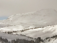
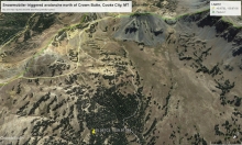
SS-N-R2-D1.5
Coordinates: 45.1771, -111.4350
Caught: 0 ; Buried: 0
Natural avalanche observed west of McAtee Basin, near Buck Ridge. Likely broke on 1/9/2019 or morning of 1/10/2019.
More Avalanche Details
SS-ASr-R1-D1-O
Elevation: 6,600
Aspect: SW
Coordinates: 44.8381, -111.3430
Caught: 0 ; Buried: 0
More Avalanche Details
SS-N-R2-D2
Coordinates: 45.0423, -109.9650
Caught: 0 ; Buried: 0
Natural avalanche on a steep east facing windloaded slope of Miller Ridge. Photo taken 1/10/2020. Likely broke Tuesday or Wednesday during the storm.
More Avalanche Details
SS-ASc-R0-D1
Elevation: 8,200
Aspect: S
Coordinates: 45.0256, -109.9370
Caught: 0 ; Buried: 0
Skier triggered slide on Town Hill. A southerly a aspect at 8200'. It was triggered with a ski ski cut nd no one was caught. Specs: about 2' deep, 50' wide, and it ran about 75' vertical.
More Avalanche Details
SS-ASu
Elevation: 9,200
Aspect: NE
Coordinates: 45.2995, -111.3200
Caught: 0 ; Buried: 0
From an email:
9200 ft - NE Aspect CT13-Q2 •Wind-lo loading f le leeward & E facing slopes •10-20 mph winds
My partner and I skied the apex of the ridge to avoid avalanche terrain, he triggered a soft slab , 1.5 ft deep, off the top of the ridge, crown 100ft wide, ran 300 ft down slope. Collapsing observed on the lower tree portions of the exit out Trail Ck.
More Avalanche Details
C-AOu-R2-D2-I
Elevation: 9,200
Aspect: SE
Coordinates: 45.3237, -111.3810
Caught: 0 ; Buried: 0
Large cornice collapse in Middle Basin. The cornice broke 10' back from the edge, 6-7' deep, and ran 800-1000' vertical. The collapse was triggered by a dog in another party.
The crown depth in the cornice was 6-7', but the snow rode up onto the interface and gouged 24" of snow out.
More Avalanche Details

Coordinates: 45.0566, -109.9510
Caught: 0 ; Buried: 0
Lots of setteling ......and lots of Cracking in the new snow interface.
More Avalanche Details
HS-AEc-R3-D2.5-O
Elevation: 10,000
Aspect: SE
Coordinates: 45.2760, -111.4360
Caught: 0 ; Buried: 0
"We triggered 3 significant persistent slabs with explosives on the south face, all in areas that had been rapidly loaded by last night’s winds. Castro’s shoulder, Upper Rodeo and Jailbait (HV) all succumbed to the load and failed 3-6’ deep on the ice crust 30-60 cm off the ground and showed impressive propaga propagation significant new snow slide in slide n failed 4-5’ deep just involving snow that had been deposited since this storm began." - BSSP
More Avalanche Details
Coordinates: 45.8586, -110.9560
Caught: 0 ; Buried: 0
From an email:
"Skied from Bracket creek to the east facing glades below Ross Peak. At lower elevations very thin snowpack. As we got higher, snow had been significantly wind effected. Experienced several shooting cracks. At 8000 ft, snow was still only 50-75cm deep with variable wind slab . Did not dig a full pit, but hand shear tests showed the wind slab was very poorly bonded to the facets beneath. Winds were swirling and increased from calm to strong throughout the day. Blowing snow mostly filled in our tracks within about 30 mins."
More Avalanche Details
SS-N-D1-O
Aspect: N
Coordinates: 45.4402, -110.9310
Caught: 0 ; Buried: 0
From an email:
"Beauty of a day up in Hyalite so long as you didn't mind the wind. The SW/W winds were cranking and clearly transporting snow all day at ridgetop (photo attached). Above 7500' we consistently found ~20cm of new snow from the storm earlier in the week on on top of a thin soft slab over small (but well developed) near surface facets. - A quick pit at 8900' on a protected 30 degree East aspect yielded no obvious slab and no propagation in tests but did show fractures along the new snow/old snow boundary and consistent deeper collapses in the buried crust-facet-sandwich. - We did notice a few recent natural avalanches on wind loaded north aspects in aprons below large cliffs and underneath large cornices (D0.5 - D1, max depth 1m, max width 30m) but these seemed to mostly be small soft storm slabs. - One recent crown near the top of the Mummy (30cm deep) looked to have run naturally on an old crust layer (photo attached) - We avoided slopes greater than 35 degrees and wind-loaded open slopes today and experienced no cracking, collapsing or avalanching where we travelled. - The next front rolled in rather quickly at 3pm with S2+ snowfall and ripping winds throughout the valley."
More Avalanche Details
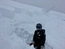
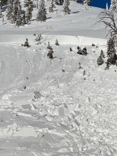
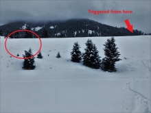
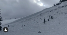
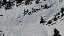
HS-AMu-R4-D3-G
Elevation: 9,300
Aspect: NE
Coordinates: 45.1719, -111.3800
Caught: 2 ; Buried: 2; Killed: 0
From one of the riders caught in the slide , "The 3 persons involved were traveling across the slope about 20-30 yards up from the tree line parallel to the ridge line in the slide area when it broke, not high marking and not traveling uphill. One rider did increase his elevation while traveling across the slope but was never more than 1/4 of the way up when the slide was triggered."
@carter.olson, "I witnessed three snowmobilers
trigger
and get caught in an avalanche at second Yellowmule (Buck Ridge) at 12:40PM today. The lead snowmobiler triggered the avalanche while descending from his high mark with the other two snowmobilers below him. The lead snowmobiler was able to run out the avalanche to a degree and made it to the edge of the runout at the bottom. The other two snowmobilers were pointed uphill when the avalanche was triggered and shot into the trees when attempting to outrun the avalanche. The female was buried to her torso and the male was buried to his waist. Both sleds were buried about three feet under the debris. The Avalanche propagated about 1500ft wide. Luckily everyone involved was not harmed, just a broken a arm on one of the buried sleds.
Luckily I was able to jump into action, yelling “Avalanche, Avalanche, Avalanche” grabbing everyone in my group’s attention. Then I told everyone to get their beacons out and put them to search and get to where we last saw the snowmobilers. On our way to the last point of sight of the snowmobilers, they all screamed out they were ok."
More Avalanche Details

HS-ABc-R4-D3-O
Elevation: 8,500
Aspect: NE
Coordinates: 45.8156, -110.9230
Caught: 0 ; Buried: 0
This slide was triggered by Bridger Bowl ski patrol during control work on Saturday (1/4/2020) on "The Drain". This is a heavily wind loaded slope on the south end of the ski area adjacent to the backcountry (Saddle Peak). It shows deeply buried persistent weak layers from early October and November were pushed to a breaking point by the recent snow and wind.
More Avalanche Details
N-R2-D2
Elevation: 9,000
Aspect: SE
Coordinates: 45.2995, -111.3200
Caught: 0 ; Buried: 0
A large avalanche crown was seen on Yellow Mountain from the Big Sky meadow village on the morning of 1/4/2020. It reportedly spanned across the entire a avalanche path
More Avalanche Details
SS-R3-D2-O
Elevation: 8,600
Aspect: SW
Coordinates: 45.3407, -111.3910
Caught: 0 ; Buried: 0
From e-mail: "Toured in Beehive today. Good snow but very windy. Pics show a large avalanche in the area where “Going Home” ends. Lighting was difficult so not that clear. There was a smaller slid
slide
t to the right of the picture and one chute from the end of “Going Home”.
The
slide
pictures took out some small trees. I was surprised how far into the low angle the debris ran.
Hard to know if this was skier triggered but there were one set of tracks coming down Going Home." Photo: A. Crawford
More Avalanche Details
SS
Coordinates: 45.8512, -110.9480
Caught: 0 ; Buried: 0
Skiers saw a recent natural avalanche near Fairy Lake on 1/3/20.
Ski patrol saw recent natural avalanche debris in Truman Gulch behind Bridger Bowl on 1/3/20.
These slides may have happened early morning on 1/3/20 or late 1/2/20.
Skiers had widespread collapsing and a a few "whumphs" of the snowpack at The Throne.
More Avalanche Details

N-R3-D2.5-O
Elevation: 9,000
Aspect: E
Coordinates: 45.7943, -110.9360
Caught: 0 ; Buried: 0
Seen from the road Friday morning (1/3). Likely ran within last 12-24 hrs.
More Avalanche Details
SS-N-D1.5
Coordinates: 45.0202, -109.9380
Caught: 0 ; Buried: 0
Multiple reports from today:
1. Noted 2 natural slab avalanches today. One was a north facing a aspect of Mt. Republic, approx. 8500', and estimated to be about 1-2' deep and 40' wide. And the other was on Town Hill, a SE as aspect bout 7,800' (photo attached).
2. No camera with me, but observed a natural on a steep roll-over E. of The Gully on Town Hill. N. aspect ~ 8,000'. New snow not well bonded to old snow surface.
3. Saw a small natural happening on the Ozarks. Small naturals on E Republic. Storm snow D1 to 1.5. Wind drifts cracked consistently and we had one localized
collapse
. The storm and winds slabs were very reactive.
More Avalanche Details

ASu-R0-D1
Elevation: 9,000
Aspect: NW
Coordinates: 45.4473, -110.9990
Caught: 0 ; Buried: 0
From an email:
"Also observed a recent slide on the northwest face of elephant, at about 9000 feet, in the second elephant glade along the blackmore trail. Wind pocket looked to be triggered by a skier on their way out, maybe 30 feet wide, ran for a 80 feet. Looks like they stayed high, just below a rock band on their exit and cut the wind slab ."
More Avalanche Details
L-N
Aspect: NE
Coordinates: 45.4402, -110.9310
Caught: 0 ; Buried: 0
From an email:
"Got hit by a pretty decent loose snow avalanche from above while topping out on Killer Piller up Flanders. Had a decent stance so I was able to hold on. Also observed more than a few coming down gullies on the other side of the drainage. It was lightly snowing all day and dead calm in the drainage, so presumably winds were cranking on the ridgetop."
More Avalanche Details
SS-ASr-R0-D1-I
Coordinates: 45.4164, -110.9700
Caught: 0 ; Buried: 0
From an email: "Remotely triggered this small wind slab while skinning into the Maid of the Mist basin. Throughout the day I continued to encounter other small, reactive wind slabs and strong winds."
More Avalanche Details
Aspect: N
Caught: 0 ; Buried: 0
Party of three skiers remote triggered avalanche with at least 6' crown off N face of Mt Porphry along rockband near summit. They had dug three pits dug on NE face ascending Mt Porphry indicating increasing stability and no clean propagation . Approx 150-210 cm deep snowpack. See attached photo.
More Avalanche Details
HS-AMu-R2-D2-O
Elevation: 10,000
Aspect: NW
Coordinates: 45.0497, -109.9640
Caught: 0 ; Buried: 0
A snowmobiler triggered this avalanche. He was not caught. This slope is below Chimney Rock next to Daisy Pass. It is a heavily wind-loaded slope and failed on facets at the ground.
More Avalanche Details
HS-AMu-R2-D2-O
Elevation: 10,000
Aspect: NE
Coordinates: 45.0524, -109.9450
Caught: 0 ; Buried: 0
Skiers reported: "Two new [ trigger unknown] avalanches on the east side of Henderson today. The first photo is from this morning (12/27/19) around 11:00. The second one appears to be much deeper and I didn't notice it until I rode back by around 2:30, so it might have occurred while I was out skiing or I just missed it this morning."
From Dave and Doug's investigation on 29 Dec:
1. The lookers left avalanche was the deepest at 6' deep of Hard Slab . Estimated 150' wide and 300' vertical. It broke on facets near the ground.
2. The avalanche to the right was 3' deep and also broke on facets near the ground. It too was heavily wind-loaded. Estimated 250' wide and 300' vertical.
More Avalanche Details

SS-N-R1-D2-U
Elevation: 10,000
Aspect: E
Coordinates: 45.0524, -109.9450
Caught: 0 ; Buried: 0
From email (12/26): "Saw some recent avalanche activity on steep east facing wind loaded slopes of Henderson and Sheep. Both avalanches looked recent and were "pockets" going in the D2, R1.5 range about 1.5-2.5' deep."
More Avalanche Details
HS-R1-D1-I
Coordinates: 45.1719, -111.3800
Caught: 0 ; Buried: 0
Small avalanche in 2nd Yellowmule. Likely broke during storm on 12/24. Less than a foot deep but ~150 ft wide.
More Avalanche Details
SS-N-R1-D2-O
Elevation: 9,000
Aspect: E
Coordinates: 44.7145, -111.3180
Caught: 0 ; Buried: 0
Two natural avalanches near Lionhead Ridge likely broke during the storm on Christmas Eve. One s slide appears to have broken on a w weak layer in the middle of the snowpack, while the other only involved the new snow. Both were less than 100 ft wide and ran a couple hundred feet. They were on south east and northeast facing slopes at around 9000 ft.
Photo: GNFAC
More Avalanche Details
HS-AF-O
Elevation: 7,900
Aspect: NW
Coordinates: 45.4388, -110.9260
Caught: 0 ; Buried: 0
Ice climbers had a very hard wind slab collapse , crack and "whumph" while approaching a climb in Flander's drainage. Winds were blowing strong and drifting snow. They noted their tracks were filled in when they left, and fresh drifts cracked when isolated.
More Avalanche Details
HS-AU-R4-D2-O
Coordinates: 45.9043, -110.9580
Caught: 0 ; Buried: 0
Riders near Fairy Lake reported this slide on Saturday 12/21. Photo: @turbo_dieshall
More Avalanche Details
HS-AMr-R2-D1.5-O
Coordinates: 45.4755, -110.9500
Caught: 0 ; Buried: 0
From IG message: "5' thick wind slab just behind little bear remote triggered riding along the ridge." @skidooin_it
More Avalanche Details
HS-N-R2-D2.5-O
Elevation: 9,800
Aspect: NE
Coordinates: 44.9918, -109.9150
Caught: 0 ; Buried: 0
Skiers with a level 2 class near Cooke City reported: "...toured into East Hayden today with the Level 2 course. We noticed some recent natural activity on the S end of the Climax path (see photo).
We dug on a N a aspect .. around 9500'. HS 100 cm, CT22 SP down 60 cm on FC above the Thanksgiving crust. ECTP21 on the basal facet layer.
The students dug on E and W aspects... around 9800'. On both aspects HS was around 110-120 cm, and both the midpack FC/crust and basal facet layers were less reactive. Between six snowpits we didn't have a single ECTP, and only a handful of CT results on either layer.
All aspects were heavily wind affected."
More Avalanche Details
SS-N
Aspect: E
Coordinates: 45.4164, -110.9700
Caught: 0 ; Buried: 0
1. From an email: The wind sure moved snow around up Hyalite last night, and our party observed several small to medium-sized releases that occured on a heavily-loaded east aspect overnight. None stepped down in the snowpack, but they certainly could have taken a person for a ride. Overalll, stability seemed to be good, with the exception of isolated wind-loaded areas.
2. From IG: Couple of small natural wind slabs around 10,200’ NE in Hyalite. Not sure exactly how recent. Played it conservative and chose to stay off a similar slope.
More Avalanche Details
Coordinates: 44.9268, -110.4510
Caught: 0 ; Buried: 0
More Avalanche Details
HS-N-R2-D2-U
Elevation: 9,000
Aspect: E
Coordinates: 45.7943, -110.9360
Caught: 0 ; Buried: 0
Avalanche crown(s) seen Wednesday (12/18), probably ran Monday or early Tuesday. Broke 200-300' across between the peaks and south central. Debris ran 1,500' vertical. Photo: GNFAC
Additional info from a skier on 12/19/19:
"Hard to tell how deep it was. Looked like 15” max maybe. Tapered off quick. Looked like probably that south wind load.
One crown was north between the peaks about 60 ft from the ridge top. Then it seemed to take the legs out of the stuff in South Central since the crown was 150 ft below ridge top. Then a little dribble made its way into Argentina bowl on the south a aspect Debris terminated right at the bottom of each chute.
Since the crown was so low I never got eyes on it. Plus it has blown in a little. I stayed high near the ridge line to the pinnacles. But it looked and felt like a bomber crust is what it ran on. Hard sl slab ith pretty small chunks in the debris.
The one picture didn’t come out well but it looked like goat tracks went right into that higher north crown. Maybe a dead goat... they are usually pretty smart though."
More Avalanche Details
SS-N-R2-D2-O
Elevation: 9,200
Aspect: NE
Coordinates: 45.0607, -111.2720
Caught: 0 ; Buried: 0
Riders reported three recent avalanches that happened on or prior to 12/15. A couple looked natural, one had a lot of tracks nearby and may have been snowmobile triggered.
More Avalanche Details
SS-N-R2-D2
Elevation: 9,800
Aspect: E
Coordinates: 45.0017, -109.9550
Caught: 0 ; Buried: 0
Went up for a closer look at a recent natural avalanche in the bowl of Mt. Republic today, just lookers left of the typical Fin ski zone. An easterly a aspect Photo: B Fredlund
More Avalanche Details
SS-N-R2-D2
Elevation: 11,000
Aspect: SE
Coordinates: 45.1212, -109.9300
Caught: 0 ; Buried: 0
More Avalanche Details
SS-N-R1-D1-U
Coordinates: 45.4029, -110.9760
Caught: 0 ; Buried: 0
While on a tour in Hyalite yesterday, we were able to find stable snow on a south aspect at 9500 feet. Although we found no propagation in our ECT, we observed a defined crust layer about 2.5 feet down which was well bonded to snow above. On some steeper pitches near rocks bands, we observed top layer slough that moved naturally. We also observed a small crown from a day or two ago that broke between two buried rocks and only ran about 50 feet down slope.
More Avalanche Details
SS-N-R2-D2-U
Elevation: 9,800
Aspect: NE
Coordinates: 44.9855, -109.9410
Caught: 0 ; Buried: 0
Photo of recent avalanche up on Amphitheater Mtn., as seen 12/15 from Silver Gate. NE a aspect around 9800'
More Avalanche Details
SS-N-R2-D2.5-O
Elevation: 9,800
Aspect: NE
Coordinates: 44.9855, -109.9410
Caught: 0 ; Buried: 0
From e-mail: "... This picture is from what I call the Sirens. Looks pretty recent. Steep terrain and repeat offender every season. We got some isolated collapses while skinning today. West face snowpit at 9600' revealed no issues with Thanksgiving later, but did get it to go 90cm deep on a Ect31, big wallop on basal facets."
More Avalanche Details
HS-AMu-R3-D2.5-O
Elevation: 9,200
Aspect: E
Coordinates: 45.0642, -110.0110
Caught: 0 ; Buried: 0
From IG post: "Pictures don’t do this monster avalanche justice. We helped the kid recover his sled, which was buried between 4and 10 feet. luckily it wasn’t him and no one was hurt." @mackleymtvet
E-mail from uninvolved group: "Incident occurred on an East aspect of the far south shoulder of Abundance. Did not witness incident or know the party involved, but arrived shortly after it occurred. Involved party was still on scene. Rider was approaching blind roll over from the top when sli slide s triggered at the visible crown. Rider attempted to bail, but both the individual and machine were carried over and through the rocks and strainers below. Rider and machine were deposited in the debris pile as seen in pictures. Rider was unharmed. Machine was pretty well trashed. Information based on first person observation and rider testimony."
More Avalanche Details

SS-AMu-R1-D2-O
Aspect: SE
Coordinates: 45.0525, -109.9620
Caught: 0 ; Buried: 0
From email: "Saw 3 different slides today, all had sled tracks near or into them, and were breaking from rocks... The other slides were smaller, had broken from rocks at the top of ridges. Also saw some cracking mid slope, on this same a aspect a ridge over down left of this photo."
Photo is of avalanche on SE
aspect
of Crown Butte.
More Avalanche Details
U-AM
Coordinates: 45.1719, -111.3800
Caught: 0 ; Buried: 0
While teaching up at Second Yellowmule we received a secondhand report of riders in the Slat Creek area triggering 4 avalanches. It sounds like no one was caught, injured, or buried.
More Avalanche Details
HS-ASr-R3-D2-O
Elevation: 9,800
Aspect: NE
Coordinates: 45.0816, -109.9600
Caught: 0 ; Buried: 0
From e-mail: "Remote triggered this one today. Knew it was up there and touchy. Took the safe line along the trees.... certainly a sign of what is possible...."
More Avalanche Details
SS-N-R2-D2-O
Elevation: 9,500
Aspect: NE
Coordinates: 45.0607, -111.2720
Caught: 0 ; Buried: 0
Forecaster obs: We rode into Taylor Fork on 12/13 and saw recent crown lines along the long ridge in Carrot basin. Appeared to be natural and broke on weak snow at the base of the snowpack. They were buried by recent snow so at least one day old, but timing is estimated.
More Avalanche Details

Coordinates: 45.0344, -109.9840
Caught: 0 ; Buried: 0
From email: "Significant collapsing throughout the day. After the first collapse , we backed off and kept slope angles well below 30°. A couple of collapses were widespread with significant settling."
More Avalanche Details
Coordinates: 44.9609, -111.1000
Caught: 0 ; Buried: 0
From an email, "Signs of instability were impossible to miss in Bacon Rind today. Lower elevations with thick trees produced localized collapsing under our skis. At higher elevations, and in open meadows, collapsing and whumpfing communicated across whole slopes, shook snow off trees, and sent birds flying.
More Avalanche Details
SS-ASc
Elevation: 8,200
Aspect: NE
Coordinates: 44.6859, -111.2900
Caught: 0 ; Buried: 0
Skiers at Targhee Pass near West Yellowstone reported: "We got a few good collapses while skinning up through east-facing low angle meadows, and got some serious cracking and collapsing while stomping on fresh wind pillows just below ridgeline on a northeast-facing slope at about 8200'. We dug down at one of the cracks and found a 35cm thick F+ slab that had failed on a layer of 4-6mm depth hoar . Cracks propagated close to 100'..."
More Avalanche Details
SS-N-R1-D1.5-O
Elevation: 9,000
Aspect: N
Coordinates: 45.1719, -111.3800
Caught: 0 ; Buried: 0
Riders reported multiple natural slab avalanches on N facing slopes.
More Avalanche Details
Coordinates: 45.0532, -109.9610
Caught: 1 ; Buried: 0
Bill Whittle of Cooke City SAR reported that one sledder triggered a slide in a terrain trap to the northwest of Lulu Pass (45.06703, -109.97180). It caught him, but he was not buried. It only buried the tail of his sled. He hit his "SPOT" rescue beacon because he was stuck.
Separately, a little while later, a rider on a rental sled was unable to ascend Daisy Pass to return to town. As he was walking up the pass and others were retrieving his sled, a 2 foot deep (est.) natural slide released on the northeast aspect of Crown Butte that missed them.
Since the storm began 26 hours ago, 1.4" of snow water equivalent fell which is estimated to be 2 feet of snow.
Winds were W-SW averaging 10-20 mph with gusts reaching 44 mph (Lulu Pass weather station)
More Avalanche Details
Elevation: 8,300
Aspect: S
Coordinates: 45.0265, -111.0480
Caught: 0 ; Buried: 0
From e-mail: "Skied up to 8300 feet on Meldrum Mountain until I succumbed to the deadfall and turned around. Poor structure with facets at the ground and low coverage. Collapsing on southerly aspects where there was enough snow. Northerly aspects were unsupportable."
More Avalanche Details
HS-ACc-R2-D3-O
Elevation: 8,500
Aspect: E
Coordinates: 45.8156, -110.9230
Caught: 0 ; Buried: 0
Ski patrol triggered two large hard slab avalanches, one in Slushman's Ravine and the other in Mundy's Bowl, by knocking large cornices down on the slope. One was 4' deep, AC-HS-R2-D3-O, ran 1150' vertical. The other was 2.5' deep, AC-HS-R2-D2-O, ran 650' vertical. This was their first control in this area for the season, so the snowpack is similar to backcountry.
More Avalanche Details
SS
Coordinates: 45.4472, -110.9620
Caught: 0 ; Buried: 0
Observations from Hyalite today:
1. When approaching the base of Mt. Blackmore this morning at roughly 8:45am we observed strong swirling winds at higher elevations (summit of Blackmore and the Elephant/Blackmore Saddle). The winds we observed were primarily loading snow onto E and SE facing aspects. Furthermore, we witnessed four naturally triggered avalanches over a twenty minute span. All slides appeared to be D1/D2 on E and SE aspects and, seemingly, restricted to the newly loaded snow.
2. My partner and I climbed Zach Attack today. We intentionally triggered numerous size 1 wind slabs in the gully approaching the climb, which has slopes up to 35 degrees. These slabs were between 5 and 15 cm thick, up to 5m wide, 4F in hardness, touchy, and failed on lower density new snow. Although none of them ran more than 20m in this terrain, it would be a different story on steeper slopes, and if you were in an exposed position they had enough mass to push you around. Strong down and cross-slope winds formed these slabs at and below treeline, while the more alpine terrain of the climb itself was scoured.
3. Skied up in the main drainage of Hyalite today. Triggered some small wind slabs and propagating cracks. We backed off our main objective (a north facing couloir ) because of these red flags and multiple crown lines on the same aspect and elevation.
More Avalanche Details
Coordinates: 45.0303, -109.9980
Caught: 0 ; Buried: 0
From an email:
"Chris and I toured up the East Ridge of Mineral today and dug a pit on a NE aspect around 9000'. HS 75 cm, mostly facets with the exception of the new snow. ECTX. We found more of a windslab on some more exposed features although it wasn't reactive for us and we saw no natural avalanches with the exception of a small slide in the couloir skier's left of the summit of Meridian. We were still a ways away but it appeared to have run on the old/new snow interface."
More Avalanche Details
SS-N-D2
Aspect: E
Coordinates: 45.7943, -110.9360
Caught: 0 ; Buried: 0
More Avalanche Details
SS-ASc-R1-D1.5-I
Elevation: 9,000
Aspect: SW
Coordinates: 45.3420, -111.3870
Caught: 0 ; Buried: 0
From Obs.: "New snow from 24 hours ago blew around the ridge tops from 11pm last night until 7am this morning ~30mph. This soft 4 finger slab was about 6”-7” deep and broke on a convex roll... We were assessing the terrain carefully and expected this result."
More Avalanche Details
L-R1-D1.5
Elevation: 8,300
Aspect: E
Coordinates: 45.7701, -110.9400
Caught: 0 ; Buried: 0
Skiers saw natural soft slabs that broke below the cornice along the ridge near Slushman's lift.
Another group reported: "I spotted a buddy skiing the lower nose and he started a couple of slow moving sluffs, well in his wake... We did see a recent point release in that zone, from a ski track , that ran over 200 feet in steep terrain."
More Avalanche Details
L-ASc-R1-D1-O
Elevation: 9,000
Aspect: W
Coordinates: 45.3407, -111.3910
Caught: 0 ; Buried: 0
We were able to trigger dry loose avalanche in the 3-5" of new snow that ran on firm underlying crusts.
More Avalanche Details

SS-AS-O
Elevation: 8,500
Aspect: NE
Coordinates: 44.7145, -111.3180
Caught: 0 ; Buried: 0
From obs.: "8500 feet Northeast aspect . Extended column test ECTP 9 Failed near the ground on prestorm facets. 60 cm total snow depth. Widespread collapsing in open terrain."
More Avalanche Details
Coordinates: 45.4050, -110.9420
Caught: 0 ; Buried: 0
From an email:
"At about 9,000ft on the northern aspect of Overlook mtn we dug a pit to the ground (90cm) and got ECTX and very stable results. We found the basal faucets to be quite rounded except for some large ones growing off rocks. About 500ft higher we found a pervasive wind slab that stretched across the face. We got some large shooting cracks while skinning and ended up turning around. Picture is attached. Before the wind picked up we found surface hoar almost 3/4 of an inch deep!
More Avalanche Details
Elevation: 10,000
Aspect: NE
Caught: 0 ; Buried: 0
Sometime last week (11/20-11/22) these large avalanches occurred on heavily wind loaded northeast facing slopes in the Absaroka. The snowpack there is thin and faceted, similar to the southern ranges and mountains near West Yellowstone. Photo: B. VandenBos
More Avalanche Details
SS-N-R1-D1.5-I
Elevation: 8,500
Coordinates: 45.8156, -110.9230
Caught: 0 ; Buried: 0
Thursday, November 21:
1. "I observed 2 natural avalanches on the slopes between the Apron and Ramp. No ski tracks in those areas. I thought I took a picture but didn’t. Looks like they both started in the rock bands below the ridge. One was small and the other was considerably larger. Hard to know if they ran today or yesterday. Looked like it was just new snow. Pretty much east as aspect
2. "Toured up to the ridge at Bridger today and traversed into Bridger Gully. At around 8,000' in the trees above the most prominent snowfield, my partner and I observed very small dry sluffs confined to the new snow. Bellow Bridger Gully, my partner was able to release a slide while traversing through rocks above his intended line. This was on an east-southeast aspect at 7,500'. Snow just a few degrees more to the east was dryer. The snowpack nearby thinned greatly on the east-southeast aspect .
Wednesday, November 20:
1. " Noted some activity (D1-D2) isolated to the new snow around rock features and ridgetops that were wind-affected. Our pit revealed a weakening and thin snowpack due to the drier weather, however, the facet growth at the ground has remained fairly slow and has maintained moisture."
More Avalanche Details
L-N-I
Elevation: 9,500
Aspect: E
Coordinates: 45.4402, -110.9310
Caught: 0 ; Buried: 0
From Doug Chabot:
I went ice climbing in Flanders and got hit with a
graupel
storm (0830) which avalanched off the climbs on east-facing slopes for over an hour. It was pretty spectacular and we found knee deep
graupel
(small, ball-bearing like grains) 200 vertical feet from the bottom of the cliffs. The climbs that we saw this on were Big Sleep, Bobo Like and Killer Pillar. The snow appears to be sliding on a razor thin ice crust under the 3" of new snow that fell last night, which was dense (estimated 15%).
I dug a hand pit to the ground and found 2' of mostly solid snow (no obvious facets) with a couple ice crusts in the upper third. A CT cut with a ski pole yielded no fractures. Elevation 8,000', east
aspect
.
More Avalanche Details
N-R0-D1-G
Elevation: 8,900
Aspect: SW
Coordinates: 45.3407, -111.3910
Caught: 0 ; Buried: 0
From an email: "I observed a wet loose avalanche that most likely occurred yesterday afternoon. Occurred at an elevation of 8,900' on a WSW aspect , along the runout of a chute sometimes referred to as "the gem". It wasn't very large, but it ripped out to the ground in sections and looked like it could do some damage if caught off guard. I assessed the snowpack next to the small slide , and found a snowpack of only 30 cm composed of facets from 0-14 cm above the ground (F hardness), a crust of large bonded grains from 14-16 cm above the ground, small facets / rounding facets from 16-23 cm above the ground, a rain crust from 23-27 cm that blended into wet snow on the surface becoming slabby in the afternoon sun."
More Avalanche Details
Elevation: 9,000
Aspect: NW
Coordinates: 45.2776, -110.5030
Caught: 1 ; Buried: 0
Outside advisory area, but seemed relevant to report a climber triggered avalanche today (12/11/2019) at around 9000 ft, on a 35 degree slope on a NW aspect . Solid size 2, triggered roughly 15m below the crown (depth 20-40 cm, width 15m) Failed on a density change below a fresh windslab, ran around 100m and deposited 1m of debris towards the bottom of the runout. HS-AF-D2/R3-I. No injuries.
More Avalanche Details
Coordinates: 45.8156, -110.9230
Caught: 0 ; Buried: 0
Two parties reported shooting crack at Bridger Bowl today (11/11/2019).
"While skinning up to the top of Powder Park lift at Bridger, we had roughly 15' cracks propagate on an E/SE aspect . A snowpit showed roughly 8" of wind slab above a few inches of facets, on top of last week's rain crust ."
More Avalanche Details
Coordinates: 45.4444, -111.0040
Caught: 0 ; Buried: 0
Natural wind slab avalanche on the N face of Mount Blackmore on 11/10/2019.
From email: "Noted recent activity on the N face which likely happened yesterday during the storm; upper half of the avalanche and crown had been scoured by wind, but the toe of the debris was still visible and had traveled quite far"
More Avalanche Details
WL-N-R1-D1
Coordinates: 45.8156, -110.9230
Caught: 0 ; Buried: 0
Several small wet loose avalanches were observed at Bridger Bowl on 11/5.
More Avalanche Details
SS-NC-R2-D1.5-I
Elevation: 9,500
Aspect: SE
Coordinates: 45.4029, -110.9760
Caught: 0 ; Buried: 0
More Avalanche Details
SS-ASc-R1-D1.5-S
Elevation: 9,500
Coordinates: 45.3407, -111.3910
Caught: 0 ; Buried: 0
From e-mail: "Skied in the the beehive area today. Triggered some small wind slabs that were sliding on a crust.
E aspect 9,100': Triggered from a stomping a small cornice , which landed on a steep slope below and popped a small wind slab .
NE aspect 10,000': Triggered while skiing through a choke point. This one was thin but ran down slope quite a ways because the terrain was steeper. It was easy to avoid by skiing off to the right, since the gully was just cross loaded a bit on the left.
SE aspect 9,800': The third was just some propagating cracks. The slope angle wasn't quite steep enough to slide here.
These instabilities appeared to be confined to areas of dense wind drifted snow on top of a crust layer and did not appear to be wide spread."
More Avalanche Details
Aspect: W
Coordinates: 45.4472, -110.9620
Caught: 0 ; Buried: 0
"I postholed up to Zach Attack today and dug a pit in the gully a few hundred feet below the route. We found about a meter of snow on the ground, the upper 65 cm being generally unconsolidated (fist-4F hardness) snow largely transported by the wind. Below that was a 5-10 cm MFcr on top of small (1-2 mm) basal facets. Higher up in the gully we found a few isolated winds slabs, and on the way my back down one of my partners felt a wumph as we crossed above a leeward convexity."
More Avalanche Details
SS-N-R1-D1-S
Elevation: 9,500
Coordinates: 45.4444, -111.0040
Caught: 0 ; Buried: 0
From obs., "Activity I observed was restricted to the new snow. A fair bit of loose snow.... Skiers on the E bowl of Blackmore triggered some D1 dry sluffage, running on a crust beneath the new snow.... No s slab activity observed until the wind started pushing more snow around this afternoon. I watched a small (D1) w wind slab build and fail as the wind picked up near the Blackmore/Elephant saddle (happened just before 2pm). S Slab couldn't have been much thicker than 15cm, broke 30-40m wide. These slabs were building rapidly..."
More Avalanche Details
SS-N-R2-D1.5-I
Elevation: 8,400
Aspect: NE
Coordinates: 45.8156, -110.9230
Caught: 0 ; Buried: 0
More Avalanche Details
SS-ASc-R0-D1-I
Aspect: S
Coordinates: 45.4444, -111.0040
Caught: 0 ; Buried: 0
Dave Zinn triggered a small wind slab off the ridge on Mt. Blackmore.
More Avalanche Details

Aspect: N
Coordinates: 45.8156, -110.9230
Caught: 0 ; Buried: 0
Went for a midday skin up Thunder Road during the maelstrom today. It was blowing gale force, mostly from the south but seemingly from all directions at times...here’s a pic from a north facing slope below Thunder Road, about midway up PK. We saw a few more shooting cracks in the flats below the top of PK, and the surface wi
wind slab
here this photo was taken was ~10 cm.
More Avalanche Details